Добрый день, Коллеги. Важное сообщение, просьба принять участие. Музей Ферсмана ищет помощь для реставрационных работ в помещении. Подробности по ссылке

Поиск по книгам
Автор(ы):Hocking R.J., Zhang Q.
Издание:Australian Centre for Geomechanics, Perth, 2022 г., 12 стр., ISBN: 978-0-6450938-3-4
Язык(и)Английский
Carrapateena block cave mine design and planning: feasibility study / Система разработки с обрушением и планирование на месторождении Каррапатина: технико-экономическое обоснование

Carrapateena is an underground sublevel cave operation. To maximise future value from the Carrapateena copper–gold resource, an expansion study has been completed to feasibility study level to assess a larger block cave expansion below the current sublevel cave. This paper will summarise Carrapateena block cave mine design and planning from pre-feasibility to feasibility study.

Автор(ы):Reddleman C.
Издание:Routledge, 2018 г., 188 стр., ISBN: 978-1-138-71257-7
Язык(и)Английский
Cartographic abstraction in contemporary art / Картографическая абстракция в современном искусстве

We see with maps. Using maps to create complex visual understandings of the world is an activity that most of us are so used to that we do not tend to consider how the maps we read help us form these understandings. Map use has become a thoroughly commonplace activity, whether we are navigating in a city using a smartphone, planning a journey across the country, or looking at artworks that include images of maps in an art gallery or on an artist’s website.

Выпуск 1
Автор(ы):Mehrtens M.B.
Издание:Economic geology, 1986 г., 5 стр.
Язык(и)Английский
Case history and problem 1: the Tonkin Springs gold mining district, Nevada, U.S.A.

Geochemical techniques played a major role in exploration of the Tonkin Springs district and ultimately led to discovery of economically significant bodies of gold mineralization. Using some of the information obtained during the exploration program, it is possible to review the geochemical environment, secondary dispersion processes and survey techniques used successfully in this part of Nevada.

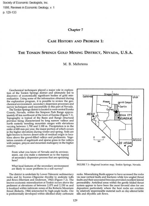
The Tonkin Springs district is located in west-central Eureka County, Nevada, within the Simpson Park Range approximately 65 km northwest of the town of Eureka (Figure 7.1). Topography is typical of the Basin and Range structural province being characterized by long narrow valleys and north easterly trending mountain ranges with elevations varying between 1,700 and 3,100 m. Precipitation is in the order of 400 mm per year, the major portion of which occurs in the higher elevations during winter and spring. Soils are light brown to brown desert soils of residual origin in locations above the gravel-filled valleys and pediments. Vegetation consists of sagebrush and sparse grass in the valleys with juniper, pinyon and mountain mahogany in the higher country.

Язык(и)Английский
Case studies of discrete element method applications in geology, geophysics and rock engineering / Тематические исследования применения метода дискретных элементов в геологии, геофизике и горной инженерии

Today, the advances in discrete modeling make it tempting to attempt to construct models that are more and more complicated by including a large number of geological structures and rock types with different properties. This leads to a dilemma if the model result is to have practical use in rock engineering (Hart, 1990): on one hand, the simulation of a large number of fractures and rock types with different properties satisfies the conceptualization of the rock mass structures and characteristics;

Издание 4
Издание:Schlumberger, Houston, 1997 г., 202 стр.
Язык(и)Английский
Cased hole log interpretation principles, applications / Принципы интерпретации каротажа обсаженных скважин, области применения

Electrical well logging was introduced to the oil industry over a half century ago. The first log was recorded on September 5, 1927, in a well in the small oil field of Pechelbronn, in Alsace, a province of northeastern France. This log, a single graph of the electrical resistivity of the rock formations cut by the borehole, was recorded by the “station” method. The downhole tool (called a sonde) was stopped at periodic intervals in the borehole, measurementsw ere made, and the calculated resistivity was hand-plotted on a graph. This procedure was repeated from station to station until the entire log was recorded.<...>

Редактор(ы):Onac B.P., Ponta G.M.L.
Издание:Springer, 2019 г., 519 стр., ISBN: 978-3-319-90745-1
Язык(и)Английский
Cave and karst systems of Romania / Пещеры и карстовые системы Румынии

Limestones make up 4400 km2 (1.8%) of Romania’s surface, which apparently is not much but they still host all known types of karst landscape and more than 12,000 caves showing a variety of genetic and morphological features. There are active caves traversed by tumultuous rivers, caves at higher levels with quiet chambers and large detrital deposits, and walls that witness the various phases of riverbed deepening.

Редактор(ы):Audra P., Auler AS., Klimchouk A., Palmer A.N., Waele J.D.
Издание:Springer, 2017 г., 902 стр., ISBN: 978-3-319-53347-6
Язык(и)Английский
Cave and karst systems of the world. Hypogene karst regions and caves of the world / Пещерные и карстовые системы мира. Гипогенные карстовые регионы и пещеры мира

Ideas that karst can develop at depth without direct genetic relationship to the surface have a long history, but remained on the periphery of karstological thinking, not influencing the traditional paradigm of karst until the last 25 years. More attention to hypogene karst since 1990, and particularly the dramatic burst of studies in this field during the last decade, has changed our notion of hypogene karst from a curiosity to one of the fundamental categories of karst, at least of compatible importance with more familiar epigene karst. <...>

Автор(ы):Gilli E.
Издание:Springer, 2019 г., 170 стр., ISBN: 978-3-319-99878-7
Язык(и)Английский
Cave and karst systems of the world. The Ankarana plateau in Madagascar. Tsingy, caves, volcanoes and sapphires / Пещеры и карстовые системы мира. Плато Анкарана на Мадагаскаре. Тцинги, пещеры, вулканы и сапфиры

I discovered the existence of the Ankarana in 1981 when I was a geology student at Nice University attending the lessons of Prof. Julian, a famous French karstologist, along with three comrades who were also cavers. One day he showed us a map from a book based on work that had been carried out in the north of Madagascar: The Ankarana Plateau by Georges Rossi (1980). At first glance we were fascinated by the landscape represented on the map. Reading the book, an important part of which was devoted to the karst areas of Red Island (Madagascar), was the incentive we needed for us to put on on our cavers’ boots and explore such a remote area. <...>

Издание 3
Автор(ы):Palmer N.A.
Редактор(ы):Watson R.A.
Издание:Cave books, 2012 г., 461 стр., ISBN: 978-0-939748-66-2
Язык(и)Английский
Cave geology / Карстовая геология

Cave geology, as treated in this book, concerns not only the geology and origin of caves, but also related aspects such as hydrology, geochemistry, and microbiology. All cave sciences are combined in the field otspeteolag)'. More than any other science, speleology is closely tied to exploration and adventure. Anyone can participate in it.

712.53