Добрый день, Коллеги. Важное сообщение, просьба принять участие. Музей Ферсмана ищет помощь для реставрационных работ в помещении. Подробности по ссылке
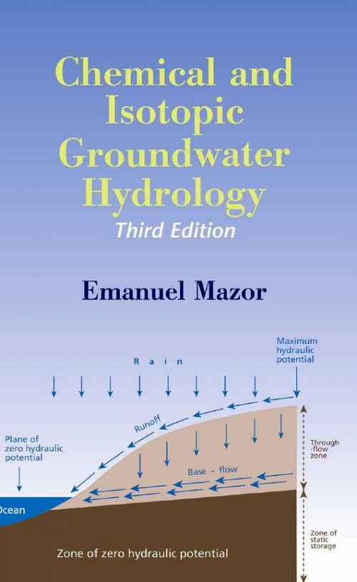
Groundwater is a vital resource in steadily increasing demand by man, but man threatens its quality and mishandles the available quantity. In order to properly manage the resource, we have to study it in detail, recognize its properties, and understand its dynamics—in large-scale regions as well as in every locally studied system. Chemical and isotopic hydrology are tailored to these challenges, and the hydrochemist has a key role as a consultant to the groundwater developers and managers, decision-makers, and environmental quality authorities
The purpose of this book is to show how essential is geology in the planning and development of cities. Town and country planning is now accepted throughout the world as a vital public service, in place of the unorganized and uncontrolled use of land in earlier days. All such planning involves the optimum use of land so that the physical development of cities and regions may best meet the needs of people. The proper use of land—for buildings, for roads, for parks—can be achieved only if the nature of the ground and subsurface conditions is known with certainty. Since the science of geology is concerned with all aspects of the crust of the earth, the use of geological information, and of geological methods to obtain new information about local subsurface conditions, should therefore be an essential part of the physical planning of all cities. <...>
In this chapter, minimal prerequisites not only for classical mechanics but also for physics, in general, are introduced. Physical dimensions, SI base units, SIderived units, and significant figures are discussed. Four coordinate systems, Cartesian coordinates, plane polar coordinates, cylindrical coordinates, and spherical coordinates are concisely shown. The coordinate transformation, which will be used in later chapters, is discussed. A Taylor series expansion is often used in physics, so that it is precisely explained. <...>
: This paper presents that in expansive clays containing montmorillonites the generalized water flow equation can be described regarding a solid volume as a reference. The water retention curves are derived by calculating both volumetric water content and the chemical potential of water in a stacking model of the 2:l layer. It is pointed out that molecular dynamics simulation is useful to analyze the characteristics of water retention curves, and that a homogenization analysis also is useful to solve the flow problems in an inhomogeneous porous body <...>
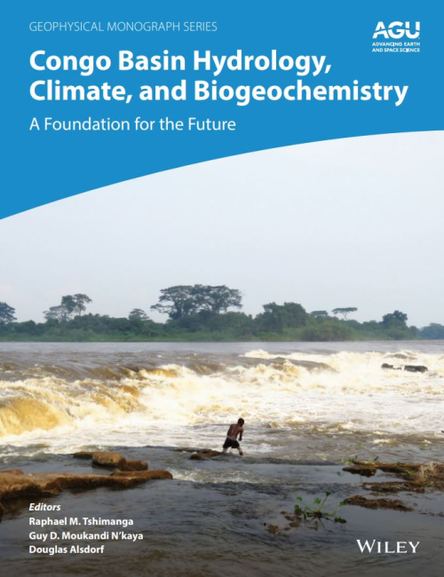
There is a general consensus that climate change is an ongoing phenomenon. This will inevitably bring about numerous environmental problems, including alterations to the hydrological cycle, which is already heavily influenced by anthropogenic activity. The available climate scenarios indicate areas where rainfall may increase or diminish, but the final outcome with respect to man and environment will, generally, be detrimental. Groundwater will be vital to alleviate some of the worst drought situations. The paper analyses the main methods for studying the relationships between climate change and groundwater, and presents the main areas in which hydrogeological research should focus in order to mitigate the likely impacts.
To the civil engineer, soil is any uncemented or weakly cemented accumulation of mineral particles formed by the weathering of rocks, the void space between the particles containing water and/or air. Weak cementation can be due to carbonates or oxides precipitated between the particles or due to organic matter. If the products of weathering remain at their original location they constitute a residual soil. If the products are transported and deposited in a different location they constitute a transported soil, the agents of transportation being gravity, wind, water and glaciers. During transportation the size and shape of particles can undergo change and the particles can be sorted into size ranges.
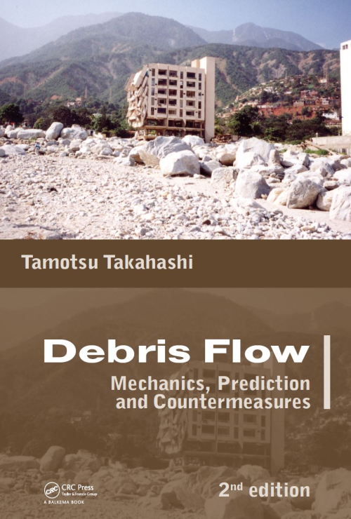
A typical debris flow is a torrential flow of a mixture of water, mud and debris that suddenly pushes ahead with a vanguard of huge, jostling and roaring boulders. It is certainly a very fearful phenomenon that causes disasters, but it is also truly a wonder of nature exciting the curiosity of researchers as to how such a phenomenon can arise. The phenomena themselves had been recognized since ancient times in Japan and given various mnemonic names to make people aware of the dangers. Although there were several detailed witness records around in 1965 when I began working for the Disaster Prevention Research Institute of Kyoto University (hereafter called DPRI), the characteristics and mechanisms of debris flows were still vague, and it was called a ‘phantasmal disaster’.
Программа DEEPSOIL предназначена для выполнения одномерного анализа отклика грунта, с ее помощью возможно осуществление: a) одномерного нелинейного анализа во временной области с созданием порового давления и без него и b) одномерного линейного эквивалентного анализа в частотной области, включая конволюцию и деконволюцию. Программа DEEPSOIL была разработана под руководством профессора Юссефа M. A. Хашаша студентами и выпускниками Университета штата Иллинойс в Урбана-Шампейн: Дуи Парком, Чи-Чин Цаем, Камило Филлипсом, Дэвидом Р. Гроховски, Дэниелом Тернером, Майклом Масгроувом, Бюнг Мин Кимом и Джозефом Хармоном. <...>