Добрый день, Коллеги. Важное сообщение, просьба принять участие. Музей Ферсмана ищет помощь для реставрационных работ в помещении. Подробности по ссылке
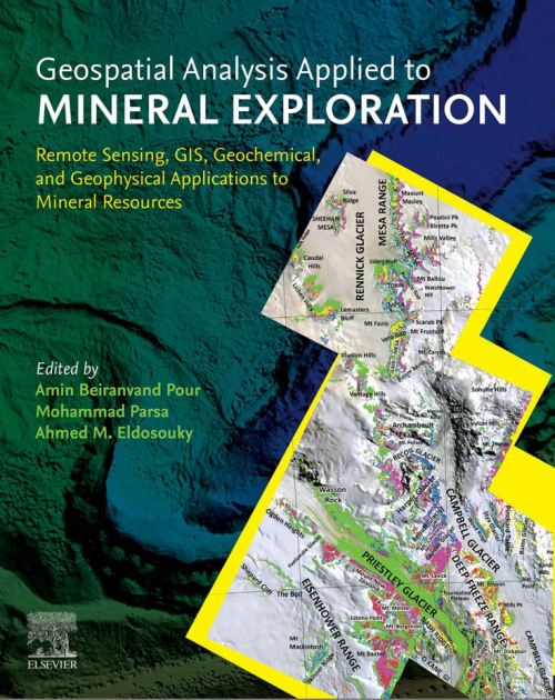
Nowadays, many surficial mineral deposits are being mined out, leaving only deep-seated mineral deposits for feeding raw materials into the industry. Therefore techniques applied to mineral exploration need to be revisited for discovering new mineral resources, which may be located in harsh and remote regions. Over the past decades, remote sensing technology and geographic information system (GIS) techniques have been incorporated into several mineral exploration projects worldwide. This aim is to bridge the knowledge gap for the geospatial-based discovery of buried, covered, and blind mineral deposits. This book details the main aspects of the state-of-the-art remote sensing imagery, geochemical data, geophysical data, geological data, and geospatial toolbox required to explore ore deposits. It covers advances in remote sensing data processing algorithms, geochemical data analysis, geophysical data analysis, and machine learning algorithms in mineral exploration. It also presents approaches on recent remote sensing and GIS-based mineral prospectivity modeling, which offer a piece of excellent information to professional earth scientists, researchers, mineral exploration communities, and mining companies <...>
Освещены общие вопросы геоинформатики, функциональные возможности горно-геологической информационной системы Micromine, основные технологические приемы создания объемных цифровых моделей геологических тел в процессе разведки месторождений полезных ископаемых.
Предназначено для студентов специальности 210502 «Прикладная геология» специализации «Геологическая съемка, поиски и разведка месторождений твердых полезных ископаемых», для специалистов геологоразведочных организаций
Proceedings of the 14th international conference of international association for computer methods and recent advances in geomechanics, Kyoto, Japan, 22–25 september 2014
Over the last half a century, constitutive models for geomaterials and numerical analysis methods have been well developed. Nowadays, numerical methods play a very important role in Geotechnical Engineering. The first pioneering conference was held at Waterways Experiment Station, Vicksburg, Mississippi, USA in 1972 under the leadership of Prof. C.S. Desai. Then, subsequent conferences were held in Blacksburg (USA) – 1976, Aachen (Germany) – 1979, Edmonton (Canada) – 1982, Nagoya (Japan) – 1985, Innsbruck (Austria) – 1988, Cairns (Australia) – 1991, Morgantown (USA) – 1994, Wuhan (China) – 1997, Tucson (USA) – 2001, Torino (Italy) – 2005, and Goa (India) – 2008. Now the conference is organized by IACMAG every three years. The last one, the 13th International Conference on Computer Methods and Advances in Geomechanics, was held in Melbourne, Australia in 2011. The 14th conference, here in Kyoto, was accepted at the Melbourne conference in 2011. This conference series is the main activity of the International Association for Computer Methods and Advances in Geomechanics founded in 70’s by Prof. C.S. Desai of the University of Arizona; the present president of IACMAG is Prof. J. Carter of the University of Newcastle. <...>
The engineer designing such soil structures as embankments, dams, or building foundations should be able to predict the safety of these against collapse or excessive deformation under various loading conditions which are deemed possible. On occasion, he may have to apply his predictive knowledge to events in natural soil or rock outcrops, subject perhaps to new, man-made conditions. Typical of this is the disastrous collapse of the mountain (Mount Toc) bounding the Vajont reservoir which occurred on 9 October 1963 in Italy (Müller 1965). Figure 1.1 shows both a sketch indicating the extent of the failure and a diagram indicating the cross section of the encountered ground movement. <...>
In his foreword to "Soft Computing for Reservoir Characterization and Modeling", Dr. Bertrand Braunschweig posed the question: "What's next?". In this companion volume, the authors have provided an imaginative and comprehensive answer. They have extended the application of soft computing techniques to methodologies used for oil exploration in general and have indicated how these increasingly popular methodologies can be integrated with our more traditional industry techniques. In this collection of articles you will find contributions from largely diverse disciplines, ranging from geostatistics and time lapse seismic to biostratigraphy and core analysis. <...>
The geodatabase supports a model of topologically integrated feature classes, similar to the coverage model. It also extends the coverage model with support for complex networks, relationships among feature classes, and other object-oriented features. The ESRI® ArcGIS applications (ArcMap, ArcCatalog, and ArcToolbox) work with geodatabases as well as with coverages <...>
The dissemination of digital spatial databases, coupled with the ever wider use of GISystems, is stimulating increasing interest in spatial analysis from outside the spatial sciences. The recognition of the spatial dimension in social science research sometimes yields different and more meaningful results than analysis which ignores it
This document defines the shapefile (.shp) spatial data format and describes why shapefiles are important. It lists the tools available in Environmental Systems Research Institute, Inc. (ESRI), software for creating shapefiles directly or converting data into shapefiles from other formats. This document also provides all the technical information necessary for writing a computer program to create shapefiles without the use of ESRI® software for organizations that want to write their own data translators. <...>
Цель этого курса - построить 3D модель, содержащую разломы, горизонты и свойства. По этой модели будут проведены подсчет запасов, проектирование свойств и подготовка карт для печати. Вы научитесь загружать данные, строить разломы по исходным данным разных типов, строить грид по модели разломов и вставлять в него горизонты (во временном домене). Затем мы преобразуем в глубину созданные горизонты (и весь грид) и разобьем модель на зоны и слои. После этого на основании информации со сквпжин мы рассчитаем петрофизические свойства модели.