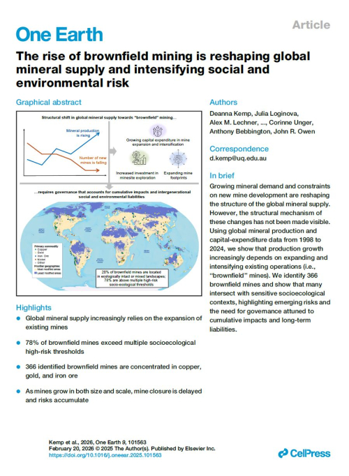
Добрый день, Коллеги. Важное сообщение, просьба принять участие. Музей Ферсмана ищет помощь для реставрационных работ в помещении. Подробности по ссылке
ПОЛЕЗНОЕ ИСКОПАЕМОЕ — природное скопление минералов в земной коре, которое может быть использовано в народном хозяйстве. Скопления полезного ископаемого образуют месторождения. Выделяются группы металлических полезных ископаемых, неметаллических полезных ископаемых и горючих полезных ископаемых.
Первая представлена самородными металлами, рудами черных, цветных, редких и радиоактивных металлов, а также рудами редкоземельных элементов.
Во вторую группу полезных ископаемых входят горно-химическое сырье (различные соли, гипс, барит, сера, фосфориты, апатиты), огнеупорное, электротехническое, пьезооптическое, тепло- и звукоизоляционное, кислото- и щелочноупорное сырье, строительные материалы, драгоценные, поделочные и технические камни.
К третьей группе полезных ископаемых относятся нефть, горючий газ, каменный и бурый уголь, торф, горючие сланцы.
По физическому состоянию полезные ископаемые делятся на твердые, жидкие и газообразные.
По генезису полезные ископаемые различают осадочные, остаточные, магматические, контактово-метасоматические и метаморфические.
Понятие полезные ископаемые условно — оно изменяется в связи с изменением потребностей народного хозяйства, развитием техники добычи и переработки минер, веществ.
Требования промышленности к качеству полезных ископаемых определяются кондициями. Закономерности размещения месторождений полезных ископаемых рассматриваются в специальных разделах геологии.
Сборник содержит доклады XV Геологического съезд Республики Коми. Приводятся новые результаты исследований по основным проблемам геологии европейского северо-востока России. Рассматриваются вопросы геологии нефти и газа, горючих, рудных и нерудных полезных ископаемых, гидрогеологии, проблемы освоения минерально-сырьевых ресурсов и недропользования, а также экологические проблемы. Представлены доклады по новым технологиям в области наук о Земле, истории геологических исследований, геологическим памятникам региона, а также по геологическому образованию.
Книга рассчитана на широкий круг специалистов в области геологии и смежных дисциплин.
The 33 independent countries and 13 territories in Latin America (which includes the Caribbean) and Canada covered in this volume encompass an area of 30.5 million square kilometers. The region, which is three times the size of the United States, had a population of 598 million, or 9% of the world total, in 2005 (U.S. Central Intelligence Agency, 2006§'; World Bank, The, 2006§).
Since the fourth edition of Geology and Economic Minerals of Canada was published in 1957 our knowledge of the geology of Canada has increased greatly. Heretofore, geological information was meagre for many parts of the country, although detailed but isolated information was available for the mineral producing areas and more accessible regions. A large part of the new knowledge has been gained in the course of systematic geological mapping; by 1957 nearly 75 per cent of Canada was still unmapped geologically whereas in 1968 only 15 per cent remained unmapped at reconnaissance scales. The important element of continuity has been established by the initial mapping, so that it is now possible to assess and present a broad range of data in both geological and tectonic terms of reference. Of the total geological research in Canada, however, only a part has been directed towards the regional type of investigation; continuing studies have been made of many matters of economic and scientific interest, not only by the Geological Survey of Canada but also by provincial organizations, the mining and petroleum industries, consultants, and the universities (see Appendix). <...>
Рассмотрена геологическая служба (ГС) как специфическая система организаций, выявляющих природные ресурсы и создающих минерально-сырьевую базу. Проанализированы вопросы организации, экономики и функционирования геологической службы. Охарактеризованы принципы, системы построения и организационного обеспечения основных направлений и видов деятельности ГС: региональные геологические исследования и геологическое картирование; исследования недр сверхглубокими скважинами и геотраверсами; геология Мирового океана;
Рассмотрена геологическая служба (ГС) как специфическая система организаций, выявляющих природные ресурсы и создающих минерально-сырьевую базу. Проанализированы вопросы организации, экономики и функционирования геологической службы. Охарактеризованы принципы, системы построения и организационного обеспечения основных направлений и видов деятельности ГС: региональные геологические исследования и геологическое картирование; исследования недр сверхглубокими скважинами и геотраверсами; геология Мирового океана;
Western Canada is the part of Canada that lies west of the Precambrian rocks of the Canadian Shield. It includes the geological regions known as the Interior Platform, the Cordilleran Orogen, and parts of the Pacific and Arctic Continental Shelves and Coastal Plains (Fig. VIII-1). The Interior Platform, underlain by Phanerozoic sedimentary rocks, is the northwestern part of the North American craton, the stable interior region of the continent. The nearly horizontal bedrock is covered by a thick mantle of glacial drift to form the plains and plateaux of the Interior Plains physiographical province. It is a region of grassland, forest, and tundra, 775,000 square miles in extent, that embraces parts of the prairie provinces of Manitoba, Saskatchewan, and Alberta, the northeast corner of British Columbia, and much of western District of Mackenzie, Northwest Territories.
Cerro Muriano es hoy un pequeño núcleo de población situado unos 16 km al N de la ciudad de Córdoba y repartido entre los términos municipales de esta y Obejo (Andalucía, España). Su territorio es cruzado por un amplio campo filoniano cuprífero (vid. HERNANDO y HERNANDO 1998), explotado, con diferentes intensidades, por los distintos pueblos y sociedades que han poblado la Sierra Morena cordobesa. De esta manera, la minería y la metalurgia del cobre han sido las actividades que han marcado el devenir de este yacimiento por el tiempo, dejando numerosas evidencias arqueológicas desde el Calcolítico hasta el siglo XX (vid. PENCO 2010). Gracias a su singularidad y buen estado de conservación –y también al empeño del director del Museo del Cobre sito en aquel lugar, D. Fernando Penco Valenzuela– este particular libro material de historia de la minería goza hoy de protección legal.
Viana, A. R., Almeida, W., Jr, Nunes, M. С. V. & Bulhoes, E. M. The economic importance of contourites Akhmetzhanov, A., Kenyon, N. H., Habgood, E., Van der Mollen, A. S., Nielsen, T., Ivanov, M. & Shashkin, P. North Atlantic contourite sand channels Llave, E., Hernandez-Molina, F. J., Somoza, L., Stow, D. A. V. & Diaz del Rio, V. Quaternary evolution of the contourite depositional system in the Gulf of Cadiz Moraes, M. A. S., Maciel, W. B., Braga, M. S. S. & Viana, A. R. Bottom-current reworked Palaeocene-Eocene deep-water reservoirs of the Campos Basin, Brazil