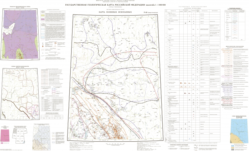
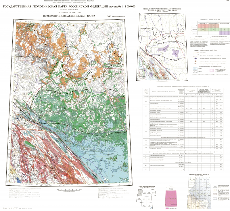
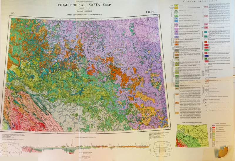
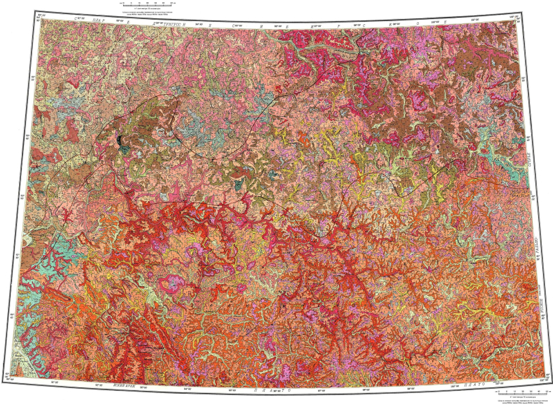
A-49 F-35-А F-35-Б F-36-Б G-35-А G-35-Б G-35-В G-35-Г G-36 G-36-А G-36-Б G-36-В G-36-Г H-35-А H-35-Б H-35-В H-35-Г H-36-А H-36-Б H-36-В H-36-Г I-35-014-4 I-41-II J-(41),(42) J-37-Б J-37-В J-40-XXIII J-42-IX J-43-XX,XXVI J-43-XXI,XXII,XXVII,XXVIII K-(37),(38) K-(38),(39) K-(40),(41) K-(52),(53) K-(52),53 K-30-XXIX K-34-009 K-34-010 K-34-011 K-34-012 K-34-022 K-34-023 K-34-024 K-34-034 K-34-035 K-34-036 K-34-046 K-34-047 K-34-048 K-34-058 K-34-059 K-34-060 K-34-070 K-34-071 K-34-072 K-34-072-Б K-34-072-Г K-34-082 K-34-083 K-34-084 K-34-095 K-34-096 K-34-VI K-35-004 K-35-005 K-35-006 K-35-007 K-35-008 K-35-009 K-35-013 K-35-014 K-35-015 K-35-016 K-35-017 K-35-018 K-35-019 K-35-020 K-35-021 K-35-025 K-35-026 K-35-027 K-35-028 K-35-029 K-35-030 K-35-031 K-35-032 K-35-037 K-35-038 K-35-039 K-35-040 K-35-041 K-35-042 K-35-043 K-35-044 K-35-049 K-35-050 K-35-051 K-35-052 K-35-053 K-35-054 K-35-055 K-35-056 K-35-061 K-35-061-В K-35-061-Г K-35-062 K-35-062-Г K-35-063 K-35-064 K-35-065 K-35-066 K-35-067 K-35-068 K-35-073 K-35-073-А K-35-073-Б K-35-073-В K-35-073-Г K-35-074 K-35-074-А K-35-074-Б K-35-074-В K-35-074-Г K-35-075 K-35-075-А K-35-075-Б K-35-075-В K-35-075-Г K-35-076 K-35-076-А K-35-076-В K-35-076-Г K-35-077 K-35-078 K-35-085 K-35-085-А; K-35-085-В K-35-085-Б K-35-086 K-35-086-Б K-35-086-Г K-35-087 K-35-087-А K-35-087-Б K-35-087-В; K-35-099-А K-35-087-Г; K-35-099-Б K-35-088 K-35-088-А K-35-088-Б K-35-088-В; K-35-100-А K-35-088-Г; K-35-100-Б K-35-089 K-35-089-А K-35-089-В; K-35-101-А K-35-099 K-35-I K-35-II K-35-V K-37,38; L-37,38 K-37-39 K-37-III K-37-IV K-37-V K-37-VI K-37-VI, XII K-37-X, XVI K-37-XI K-37-XII K-37-XVIII K-37-XXIV K-37-В K-37-Г K-38-I K-38-I,VII K-38-II K-38-III K-38-IV K-38-IX K-38-IX,XV K-38-V K-38-VI K-38-VII K-38-VIII,XIV K-38-X K-38-XI K-38-XII K-38-XIV K-38-XIX K-38-XVI K-38-XVII K-38-XVIII K-38-XVIII; K-39-XIII K-38-XX K-38-XXI K-38-XXII K-38-XXIX K-38-XXVI K-38-XXVIII K-38-XXXIV K-38-XXXVI K-39-IV K-39-V K-39-VI K-39-X K-39-XI K-39-XII K-39-XIX,XX K-39-XVII K-39-XVIII K-39-XXIII K-39-XXIV; K-40-XIX K-39-XXIX,XXX K-39-XXV K-39-XXVI K-39-XXXI K-39-XXXII K-39-XXXIII K-39-XXXV; J-39-V K-39-XXXVI K-40-I K-40-II K-40-III K-40-IV K-40-V K-40-VII K-40-X K-40-XI K-40-XII K-40-XV K-40-XVI K-40-XVII K-40-XVIII K-40-XX K-40-XXI K-40-XXII K-40-XXIII K-40-XXIV K-40-XXIX K-40-XXV K-40-XXVI K-40-XXVII K-40-XXVIII K-40-XXX K-40-XXXI K-40-XXXII K-40-XXXIII K-40-XXXIV K-40-XXXV K-41-A K-41-I K-41-II K-41-III K-41-IV K-41-IX K-41-V K-41-VI K-41-VII K-41-VIII K-41-XI K-41-XIII K-41-XIV K-41-XIX K-41-XV K-41-XVI K-41-XVII K-41-XX K-41-XXI K-41-XXII K-41-XXIII K-41-XXIX K-41-XXV K-41-XXVI K-41-XXVII K-41-XXVIII K-41-XXX K-41-XXXI K-41-XXXII K-41-XXXIII K-41-XXXIV K-41-XXXV K-41-Б K-42-A K-42-I K-42-II K-42-III K-42-IV K-42-IX K-42-V K-42-VI K-42-XI K-42-XIII K-42-XIV K-42-XV K-42-XVII K-42-XX K-42-XXI K-42-XXII K-42-XXIII K-42-XXIV K-42-XXV K-42-XXVI K-42-XXVII K-42-XXVIII K-42-XXXII K-42-XXXIII K-42-Б K-42-В K-42-Г K-43-I K-43-II K-43-IV K-43-IX K-43-V K-43-VII K-43-XI K-43-XII K-43-XIV K-43-XIX K-43-XVI K-43-XXII K-43-XXIV K-43-XXV K-43-XXVII K-43-XXVIII K-43-XXX K-43-XXXI K-43-XXXII K-43-XXXIII K-43-XXXIV K-43-XXXV K-43-А K-43-Б K-44-I K-44-II K-44-III K-44-IX K-44-VII K-44-VIII K-44-XIII K-44-XIV K-44-XIX K-44-XV K-44-А K-52-VI K-52-XI K-52-XI,XVII K-52-XII,XVIII K-52-XVII K-52-XXI K-53-I K-53-II K-53-III K-53-IV K-53-IX K-53-VII K-53-VIII K-55-II K-55-II, L-55-XXXII K-55-III K-55-III(II) L-(35),(36) L-(36),(37) L-(37),(38) L-(38),(39) L-(39),(40) L-(40),(41) L-(42) L-(42),(43) L-(43),(44) L-(44) L-(44),(45) L-(44),(45) L-(52),(53) L-(52),53; (K-52,53) L-(53),(54) L-(53),54 L-(54),(55); K-(55) L-34-142 L-34-V L-34-VI L-34-X L-34-XI L-34-XII L-34-XV L-34-XVI L-34-XVII L-34-XVIII L-34-XXI L-34-XXII L-34-XXIII L-34-XXIV L-34-XXIX L-34-XXVIII L-34-XXX L-34-XXXV L-34-XXXVI L-35-138 L-35-139 L-35-I L-35-II L-35-III L-35-IV L-35-IX L-35-VI L-35-VII L-35-VIII L-35-X L-35-XIII L-35-XIV L-35-XIX L-35-XV L-35-XVI L-35-XVII L-35-XVIII L-35-XX L-35-XXI L-35-XXII L-35-XXIII,XXIX L-35-XXIV,XXX L-35-XXIX L-35-XXV L-35-XXVI L-35-XXVII L-35-XXVIII L-35-XXX L-35-XXXI L-35-XXXII L-35-XXXIII L-35-XXXIV L-35-XXXV L-36-I L-36-II L-36-III L-36-IV L-36-IX L-36-V L-36-VI L-36-VII L-36-VIII L-36-X L-36-XI L-36-XII L-36-XIII,XIX L-36-XIV L-36-XV L-36-XVI L-36-XVII L-36-XVIII L-36-XXI L-36-XXI,XXII,XXVII L-36-XXII L-36-XXIII L-36-XXIV L-36-XXIX L-36-XXIX,XXXV L-36-XXVIII L-36-XXVIII,XXXIV L-36-XXX L-36-XXXIV L-36-XXXIV,XXXV L-36-XXXV L-36; K-36 L-37 L-37-I L-37-II L-37-III L-37-IV L-37-IX L-37-V L-37-VI L-37-VII L-37-VIII L-37-VIII,IX L-37-X L-37-XI L-37-XIV L-37-XIX L-37-XIX,XXV L-37-XV L-37-XVII L-37-XX L-37-XXI L-37-XXII L-37-XXIII L-37-XXIV L-37-XXIX L-37-XXV L-37-XXVI L-37-XXVI,XXXII L-37-XXVII L-37-XXVIII L-37-XXX L-37-XXXII L-37-XXXIII L-37-XXXIV L-37-XXXV L-37-XXXVI L-38 L-38-I L-38-II L-38-III L-38-IX L-38-VII L-38-VIII L-38-XI L-38-XII L-38-XIII L-38-XIX L-38-XV L-38-XVI L-38-XVII L-38-XVIII L-38-XX L-38-XXI L-38-XXII L-38-XXIII L-38-XXIV L-38-XXIX L-38-XXV L-38-XXVI L-38-XXVII L-38-XXVIII L-38-XXX L-38-XXXI L-38-XXXII L-38-XXXIII L-38-XXXIV L-38-XXXV,XXXVI L-39 L-39-I L-39-II L-39-III L-39-IV L-39-IX L-39-V L-39-VII L-39-X L-39-XI L-39-XIII L-39-XXIX L-39-XXXIII L-39-XXXIV L-39-XXXV L-39-XXXVI L-40-I L-40-II L-40-IV L-40-V L-40-X L-40-XI L-40-XII L-40-XIX L-40-XV L-40-XVI L-40-XXIII L-40-XXIV; L-41-XIX L-40-XXIX L-40-XXXI L-40-XXXII L-40-XXXIII L-40-XXXIV L-40-XXXV L-41-I L-41-II L-41-III L-41-IV L-41-IX L-41-V L-41-VI L-41-VIII L-41-X L-41-XI L-41-XII L-41-XIII L-41-XIV L-41-XV L-41-XX L-41-XXI L-41-XXVI L-41-XXVII L-41-XXVIII L-41-XXX L-41-XXXII L-41-XXXIII L-41-XXXIV L-41-В L-41-Г L-42 L-42-I L-42-II L-42-VII L-42-X L-42-XI L-42-XIII L-42-XIV L-42-XIX L-42-XV L-42-XVI L-42-XVII L-42-XX L-42-XXI L-42-XXII L-42-XXV L-42-XXVI L-42-XXVII L-42-XXVIII L-42-XXX L-42-XXXI L-42-XXXII L-42-XXXIII L-42-XXXIV L-42-XXXV L-42-XXXVI L-42-А L-42-Б L-42-В L-42-Г L-43-I L-43-IV L-43-IX L-43-VI L-43-VII L-43-VIII L-43-XII L-43-XIV L-43-XVI L-43-XVII L-43-XVIII L-43-XXI L-43-XXII L-43-XXIII L-43-XXIV L-43-XXIX L-43-XXVII L-43-XXVIII L-43-XXXI L-43-XXXIV L-43-XXXVI L-43-В L-43-Г L-44-A L-44-I L-44-II L-44-III L-44-IV L-44-IV,X L-44-IX L-44-V L-44-VI,XII L-44-VII L-44-VIII L-44-X L-44-XI L-44-XIII L-44-XIV L-44-XIX L-44-XV L-44-XVI L-44-XVII L-44-XX L-44-XXIII,XXIX L-44-XXV L-44-XXVI L-44-XXXI L-44-XXXIII L-44-Б L-44-В L-44-Г L-45-VIII L-45-А L-52-(V),VI L-52-V L-52-VI L-52-XXX L-52-XXXVI L-53 L-53-I L-53-III L-53-IV L-53-IX L-53-V L-53-VI L-53-XII L-53-XIV,XV L-53-XV L-53-XVI L-53-XVII L-53-XVIII; L-54-XIII L-53-XX L-53-XXI L-53-XXII L-53-XXIII L-53-XXIV L-53-XXIX,XXX,XXXV L-53-XXV L-53-XXVI L-53-XXVII L-53-XXVIII L-53-XXXI L-53-XXXII L-53-XXXIII L-53-XXXIV L-53-XXXIV,XXXV L-54-I L-54-II L-54-IV,V L-54-VII L-54-X,XI L-54-XII L-54-XVI,XXII L-54-XVII,XXIII L-54-XVIII L-55-XVIII,XXIV L-55-XVIII; L-56-XIII L-55-XXII,XXIII L-55-XXII,XXVIII,XXXIV L-55-XXIII,XXIX L-55-XXIV; L-56-XIX L-55-XXIX L-55-XXVIII L-55-XXXII L-55-XXXIII L-55-XXXIV L-56-II,III,VII,VIII,IX L-56-III,IV; M-56-XXXIII,XXXIV L-56-XIII L-56-XIX M-(34),(35) M-(35),36 M-(38),39 M-(44),45 M-(47),48 M-(50),(51) M-(53),54,(55) M-(53)54 M-34-VI M-34-XXIX M-34-XXX M-34-XXXV; L-34-V M-35-I M-35-II M-35-III M-35-IV M-35-IX M-35-V M-35-VI M-35-VII; M-34-XII M-35-VIII M-35-X M-35-XI M-35-XII M-35-XIII M-35-XIV M-35-XV M-35-XVI M-35-XVII M-35-XVIII M-35-XX M-35-XXI M-35-XXII M-35-XXIII M-35-XXIV M-35-XXIX M-35-XXV M-35-XXVI M-35-XXVII M-35-XXVIII M-35-XXX M-35-XXXII; L-35-II M-35-XXXIII M-35-XXXV M-35-XXXVI M-36-II M-36-III M-36-IV M-36-V M-36-VI M-36-VII M-36-VIII M-36-X M-36-XI M-36-XII M-36-XIII M-36-XIX M-36-XV M-36-XVI M-36-XVII M-36-XVIII M-36-XX M-36-XXI M-36-XXII M-36-XXIII M-36-XXIV M-36-XXV M-36-XXVI M-36-XXVII M-36-XXVIII M-36-XXX M-36-XXXI M-36-XXXII M-36-XXXIII M-36-XXXIV M-36-XXXV M-36-XXXVI M-37 M-37,(38) M-37-I M-37-II M-37-III M-37-IV M-37-IX M-37-V M-37-VI M-37-VII M-37-VIII M-37-X M-37-XI M-37-XII M-37-XIII M-37-XIV M-37-XIX M-37-XV M-37-XVI M-37-XVII M-37-XVIII M-37-XX M-37-XXI M-37-XXII M-37-XXIII M-37-XXIV M-37-XXIX M-37-XXV M-37-XXVI M-37-XXVII M-37-XXVIII M-37-XXX M-37-XXXI M-37-XXXII M-37-XXXIII M-37-XXXIV M-37-XXXV M-37-XXXVI M-38 M-38-I M-38-II M-38-III M-38-IV M-38-IX M-38-V M-38-VI M-38-VII M-38-VIII M-38-X M-38-XI M-38-XII M-38-XIII M-38-XIV M-38-XIX M-38-XV M-38-XVI M-38-XVIII M-38-XX M-38-XXI M-38-XXII M-38-XXIV M-38-XXV M-38-XXVI M-38-XXVII M-38-XXVIII M-38-XXX M-38-XXXI M-38-XXXII M-38-XXXIII M-39 M-39-I M-39-II M-39-III M-39-IV M-39-IX M-39-V M-39-VI M-39-VIII M-39-X M-39-XI M-39-XII M-39-XIII M-39-XIV M-39-XIX M-39-XV M-39-XVI M-39-XVII M-39-XVIII M-39-XX M-39-XXI M-39-XXII M-39-XXIII M-39-XXIV M-39-XXIX M-39-XXV M-39-XXVI M-39-XXVII M-39-XXVIII M-39-XXX M-39-XXXI M-39-XXXII M-39-XXXIII M-39-XXXIV M-39-XXXV M-40,(41) M-40-I M-40-II M-40-III M-40-IV M-40-IX M-40-V M-40-VI M-40-VII M-40-VIII M-40-X M-40-XI M-40-XII M-40-XII,XVIII M-40-XIII M-40-XIV M-40-XVI M-40-XVIII M-40-XX M-40-XXI M-40-XXII M-40-XXIX M-40-XXV M-40-XXVI M-40-XXVII M-40-XXVIII M-40-XXXI M-40-XXXII M-40-XXXIII M-40-XXXIV M-40-XXXV M-40-XXXVI M-41-(II),VIII M-41-I M-41-II M-41-III M-41-IX M-41-V M-41-VI M-41-VII M-41-VII,(XIII) M-41-VIII M-41-X M-41-XI M-41-XII M-41-XIII M-41-XIV M-41-XIX M-41-XV M-41-XVI M-41-XVII M-41-XVIII M-41-XX M-41-XXI M-41-XXII M-41-XXIV M-41-XXIX M-41-XXVI M-41-XXVII M-41-XXVIII M-41-XXXV M-41-XXXVI M-42-II M-42-III M-42-IV M-42-IX M-42-V M-42-VI M-42-VII M-42-VIII M-42-X M-42-XI M-42-XIII M-42-XIV M-42-XIX M-42-XV M-42-XVI M-42-XVII M-42-XX M-42-XXI M-42-XXII M-42-XXIX M-42-XXV M-42-XXVI M-42-XXVII M-42-XXVIII M-42-XXX M-42-XXXI M-42-XXXII M-42-XXXIV M-42-XXXVI M-43-XI M-43-XII M-43-XVI M-43-XVII M-43-XVIII M-43-XXIII M-43-XXIV M-43-XXIX M-43-XXVI M-43-XXVII M-43-XXVIII M-43-XXXI M-43-XXXII M-43-XXXV M-43-В M-44 M-44-I M-44-II M-44-III M-44-IV M-44-IX M-44-V M-44-VI M-44-VIII M-44-X M-44-XI M-44-XII M-44-XIV M-44-XV M-44-XVI M-44-XVII M-44-XVIII M-44-XXII M-44-XXIII M-44-XXIV M-44-XXV M-44-XXXI M-44-XXXII M-44-XXXIII M-44-XXXIV M-44-XXXV M-44-XXXVI M-44-А M-44-Б M-44-В M-44-Г M-45 M-45-I M-45-II M-45-III M-45-IV M-45-IX M-45-V M-45-VI M-45-VII M-45-VIII M-45-X M-45-XI M-45-XII M-45-XIII M-45-XIV M-45-XV M-45-XVI M-45-XVII M-45-XVIII M-45-XX M-45-XXI M-45-XXII,XXVIII M-45-XXIII,XXIX M-45-XXIV M-45-А M-45-В M-46 M-46,(47) M-46-I M-46-II M-46-III M-46-IV M-46-IX M-46-V M-46-VI M-46-VII M-46-VIII M-46-X M-46-XI M-46-XII M-46-XIII M-46-XIV M-46-XVII M-46-XVIII,XXIV M-47 M-47-I M-47-II M-47-III M-47-IV M-47-V M-47-VI M-47-VII M-47-VIII M-47-XIII,XIX M-47-XIV,XV,XX M-48 M-48-I M-48-II M-48-III M-48-IV M-48-IX M-48-V M-48-VI M-48-VII M-48-VIII M-48-X M-48-X,XVI M-48-XI M-48-XII M-48-XIII M-48-XIV M-48-XV M-48-XVI M-48-XVII M-48-XVIII M-48-XXIV M-48-XXIX M-49 M-49,(50) M-49-I M-49-II M-49-III M-49-IV M-49-IX M-49-V M-49-VI M-49-VII M-49-VIII M-49-X M-49-XI M-49-XII M-49-XIII M-49-XIV M-49-XIX M-49-XV M-49-XVI M-49-XVII M-49-XVIII M-49-XVIII,XXIV M-49-XXI,XXVII M-49-XXII,XXVIII M-49-XXIII M-49-XXIV M-50 M-50-I M-50-II M-50-III M-50-IV M-50-IX M-50-V M-50-VI M-50-VII M-50-VIII M-50-X M-50-XI M-50-XII M-50-XIII M-50-XIV,XX M-50-XV,XXI M-50-XVI M-50-XVII M-50-XVIII M-50-XXII M-50-XXIII M-51-I M-52 M-52,(53) M-52-(XXXV),XXXVI M-52-I M-52-II M-52-III M-52-IV M-52-IX M-52-V M-52-VI M-52-VII,VIII M-52-X M-52-XI M-52-XII M-52-XIV M-52-XV M-52-XVI M-52-XVII M-52-XVIII M-52-XX M-52-XXI M-52-XXII M-52-XXIII M-52-XXIV M-52-XXIX M-52-XXVIII M-52-XXX M-52-XXXV M-52-XXXVI M-53 M-53-I M-53-II M-53-III M-53-IV M-53-IX M-53-V M-53-VI M-53-VII M-53-VIII M-53-X M-53-XI M-53-XII M-53-XIII M-53-XIV M-53-XIX M-53-XV M-53-XVI M-53-XVII M-53-XVIII M-53-XX M-53-XXI M-53-XXII M-53-XXIII M-53-XXIV M-53-XXIX M-53-XXV M-53-XXVI M-53-XXVII M-53-XXVIII M-53-XXX M-53-XXXI M-53-XXXII M-53-XXXIII M-53-XXXIV M-53-XXXV M-53-XXXVI M-54 M-54, M-55, L-54 M-54-I M-54-II M-54-III M-54-IV M-54-IX M-54-V M-54-VI M-54-VII M-54-VIII M-54-XI M-54-XII M-54-XIII M-54-XIV M-54-XIX M-54-XV M-54-XVII M-54-XVIII M-54-XX M-54-XXI M-54-XXIII M-54-XXIV M-54-XXIV,XXX M-54-XXV M-54-XXVI M-54-XXVII M-54-XXVIII,XXIX M-54-XXXI M-54-XXXII,XXXIII M-54-XXXIV,XXXV M-55-XIX M-55-XXV,XXXI M-56-XII,XVII,XVIII,XXIV; M-57-VII,XIII M-56-XXIII,XXIX M-56-XXVIII,XXIX,XXXIV,XXXV M-56/57 M-57-I M-57-II,III M-57-VII,XIII N-(34),(35) N-(35),36 N-(44),45 N-(47),48 N-(50),51 N-(53),54 N-(56),57 N-34 N-34-IV N-34-VIII,IX N-34-X N-34-XI N-35 N-35-V N-35-VI N-36 N-36-I N-36-II N-36-III N-36-IV N-36-IX N-36-V N-36-VI N-36-VII N-36-VIII N-36-X N-36-XI N-36-XII N-36-XIV N-36-XV N-36-XVI N-36-XVII N-36-XVIII N-36-XX N-36-XXI N-36-XXII N-36-XXIII N-36-XXIV N-36-XXIX N-36-XXVII N-36-XXVIII N-36-XXX N-36-XXXII N-36-XXXIII N-36-XXXIV N-36-XXXV N-36-XXXVI N-36; M-(36) N-37 N-37,(38) N-37-I N-37-II N-37-III N-37-IV N-37-IX N-37-V N-37-VI N-37-VII N-37-VIII N-37-X N-37-XI N-37-XII N-37-XIII N-37-XIV N-37-XIX N-37-XV N-37-XVI N-37-XVII N-37-XVIII N-37-XX N-37-XXI N-37-XXII N-37-XXIII N-37-XXIV N-37-XXIX N-37-XXV N-37-XXVI N-37-XXVII N-37-XXVIII N-37-XXX N-37-XXX; N-38-XXV N-37-XXXI N-37-XXXII N-37-XXXIII N-37-XXXIV N-37-XXXV N-37-XXXVI N-37-XXXVI; N-38-XXXI N-38 N-38,(39) N-38-I N-38-II N-38-III N-38-IV N-38-IX N-38-V N-38-VI N-38-VII N-38-VIII N-38-X N-38-XI N-38-XII N-38-XIII N-38-XIV N-38-XIX N-38-XV N-38-XVI N-38-XVII N-38-XVIII N-38-XX N-38-XXI N-38-XXII N-38-XXIII N-38-XXIV N-38-XXIX N-38-XXV N-38-XXVII N-38-XXVIII N-38-XXX N-38-XXXI N-38-XXXII N-38-XXXIII N-38-XXXIV N-38-XXXV N-38-XXXVI N-39 N-39-I N-39-II N-39-III N-39-IV N-39-IX N-39-V N-39-VI N-39-VII N-39-VIII N-39-X N-39-XI N-39-XIII N-39-XIX N-39-XV N-39-XVI N-39-XVII N-39-XX N-39-XXI N-39-XXII N-39-XXIII N-39-XXV N-39-XXVI N-39-XXVII N-39-XXVIII N-39-XXXI N-39-XXXII N-39-XXXIII N-39-XXXV N-39-XXXVI N-40 N-40,(41) N-40-I N-40-II N-40-III N-40-IV N-40-IX N-40-V N-40-VI N-40-VII N-40-VIII N-40-X N-40-XI N-40-XII N-40-XIII N-40-XIV N-40-XIX N-40-XV N-40-XVI N-40-XVII N-40-XVIII N-40-XX N-40-XXI N-40-XXII N-40-XXIII N-40-XXIV N-40-XXIX N-40-XXVI N-40-XXVII N-40-XXVIII N-40-XXX N-40-XXXII N-40-XXXIII N-40-XXXIV N-40-XXXV N-40-XXXVI N-41 N-41-I N-41-II N-41-III N-41-VII N-41-VIII N-41-XIII N-41-XIV N-41-XIX N-41-XVII N-41-XVIII N-41-XX N-41-XXI N-41-XXV N-41-XXVI,(XXVII) N-41-XXXI,XXXII N-42 N-42-III N-42-IV N-42-IX N-42-V N-42-VI N-42-X N-42-XI N-42-XII N-42-XIII N-42-XVII N-42-XVIII N-43 N-43,(44) N-43-I N-43-II N-43-III N-43-IV N-43-IX N-43-V N-43-VI N-43-VII N-43-VIII N-43-X N-43-XI N-43-XII N-43-XIII N-43-XIV N-43-XIX N-43-XIX,XX N-43-XV N-43-XVI N-43-XVII,XXIII N-43-XVIII N-43-XX N-43-XXI N-43-XXII N-43-XXIII N-43-XXIV N-43-XXX N-44 N-44-I N-44-II N-44-III N-44-IV N-44-IX N-44-V N-44-VI N-44-VII N-44-VIII N-44-X N-44-XI N-44-XII N-44-XIII N-44-XIV N-44-XIX N-44-XV N-44-XVI N-44-XVII N-44-XVIII N-44-XX N-44-XXI N-44-XXII N-44-XXIII N-44-XXV N-44-XXVI N-44-XXVII N-44-XXXI N-44-XXXIII N-44-XXXIV N-44-XXXV N-44-XXXVI N-45 N-45-I N-45-II N-45-III N-45-IV N-45-IX N-45-V N-45-VI N-45-VII N-45-VIII N-45-X N-45-XI N-45-XII N-45-XIII N-45-XIV N-45-XIX N-45-XV N-45-XVI N-45-XVII N-45-XVIII N-45-XX N-45-XXI N-45-XXII N-45-XXIII N-45-XXIV N-45-XXIX N-45-XXV N-45-XXVI N-45-XXVII N-45-XXVIII N-45-XXX N-45-XXXI N-45-XXXII N-45-XXXIII N-45-XXXIV N-45-XXXV N-45-XXXVI N-46 N-46,(47) N-46-I N-46-II N-46-III N-46-IV N-46-IX N-46-V N-46-VI N-46-VII N-46-VIII N-46-X N-46-XI N-46-XII N-46-XIII N-46-XIV N-46-XIX N-46-XV N-46-XVI N-46-XVII N-46-XVIII N-46-XX N-46-XXI N-46-XXII N-46-XXIII N-46-XXIV N-46-XXIX N-46-XXV N-46-XXVI N-46-XXVII N-46-XXVIII N-46-XXX N-46-XXXI N-46-XXXII N-46-XXXIII N-46-XXXIV N-46-XXXV N-46-XXXVI N-47 N-47-B N-47-I N-47-II N-47-III N-47-IV N-47-IX N-47-V N-47-VI N-47-VII N-47-VIII N-47-X N-47-XI N-47-XII N-47-XIII N-47-XIV N-47-XIX N-47-XV N-47-XVI N-47-XVII N-47-XVIII N-47-XX N-47-XXI N-47-XXII N-47-XXIII N-47-XXIV N-47-XXIX N-47-XXV N-47-XXVI N-47-XXVII N-47-XXVIII N-47-XXX N-47-XXXI N-47-XXXII N-47-XXXIII N-47-XXXIV N-47-XXXV N-47-XXXVI N-48 N-48-I N-48-II N-48-III N-48-IV N-48-IX N-48-V N-48-VI N-48-VI; N-49-I N-48-VII N-48-VIII N-48-X N-48-XI N-48-XII N-48-XIII N-48-XIV N-48-XIX N-48-XV N-48-XVI N-48-XVII N-48-XVIII N-48-XX N-48-XXI N-48-XXII N-48-XXIII N-48-XXIV N-48-XXIX N-48-XXV N-48-XXVI N-48-XXVII N-48-XXVIII N-48-XXX N-48-XXXI N-48-XXXII N-48-XXXIII N-48-XXXIV N-48-XXXV N-48-XXXVI N-49 N-49,(50) N-49-I N-49-II N-49-III N-49-IV N-49-IX N-49-V N-49-VI N-49-VII N-49-VIII N-49-X N-49-XI N-49-XII N-49-XIII N-49-XIV N-49-XIX N-49-XV N-49-XVI N-49-XVII N-49-XVIII N-49-XX N-49-XXI N-49-XXII N-49-XXIII N-49-XXIV N-49-XXIX N-49-XXV N-49-XXVI N-49-XXVII N-49-XXVIII N-49-XXX N-49-XXXI N-49-XXXII N-49-XXXIII N-49-XXXIV N-49-XXXV N-49-XXXVI N-50 N-50-I N-50-II N-50-III N-50-IV N-50-IX N-50-V N-50-VI N-50-VII N-50-VIII N-50-X N-50-XI N-50-XII N-50-XIII N-50-XIV N-50-XIX N-50-XV N-50-XVI N-50-XVII N-50-XVIII N-50-XX N-50-XXI N-50-XXII N-50-XXIII N-50-XXIV N-50-XXIX N-50-XXV N-50-XXVI N-50-XXVII N-50-XXVIII N-50-XXX N-50-XXXI N-50-XXXII N-50-XXXIII N-50-XXXIV N-50-XXXV N-50-XXXVI N-51 N-51-I N-51-II N-51-III N-51-IV N-51-IX N-51-V N-51-VI N-51-VII N-51-VIII N-51-X N-51-XI N-51-XII N-51-XIII N-51-XIV N-51-XIX N-51-XV N-51-XVI N-51-XVII N-51-XVIII N-51-XX,XXVI N-51-XXI N-51-XXII N-51-XXIII N-51-XXIII,XXIX N-51-XXIV N-51-XXIX N-51-XXV N-51-XXX N-51-XXXI N-51; (M-51) N-52 N-52,(53) N-52-I N-52-II N-52-III N-52-IV N-52-IX N-52-V N-52-VI N-52-VII N-52-VIII N-52-X N-52-XI N-52-XII N-52-XIII N-52-XIV N-52-XIX N-52-XV N-52-XVI N-52-XVII N-52-XVIII N-52-XX N-52-XXI N-52-XXII N-52-XXIII N-52-XXIV N-52-XXIX N-52-XXV N-52-XXVI N-52-XXVII N-52-XXVIII N-52-XXX N-52-XXXI N-52-XXXII N-52-XXXIII N-52-XXXIV N-52-XXXV N-52-XXXVI N-53 N-53-I N-53-II N-53-III N-53-IV N-53-IX N-53-V,VI N-53-VII N-53-VIII N-53-X N-53-XI N-53-XII N-53-XIII N-53-XIV N-53-XIX N-53-XV N-53-XVI N-53-XVII N-53-XVIII N-53-XX N-53-XXI N-53-XXII N-53-XXIII N-53-XXIV N-53-XXIX N-53-XXV N-53-XXVI N-53-XXVII N-53-XXVIII N-53-XXX N-53-XXXI N-53-XXXII N-53-XXXIII N-53-XXXIV N-53-XXXV N-53-XXXVI N-54 N-54-VII N-54-XIII N-54-XIV,XV N-54-XIX N-54-XVII N-54-XX N-54-XXI N-54-XXII,XXIII N-54-XXII,XXVIII N-54-XXIII,XXIV N-54-XXIV N-54-XXIX N-54-XXIX,XXX N-54-XXV N-54-XXVI N-54-XXVII N-54-XXX N-54-XXXI N-54-XXXII N-54-XXXIII N-54-XXXIV N-54-XXXV N-54-XXXVI N-56-VI; N-57-I N-56-XII; N-57-VII N-57 N-57-II N-57-III N-57-IV N-57-IX N-57-V N-57-VI; N-58-I N-57-VIII N-57-X N-57-XI N-57-XII,XVIII; N-58-VII N-57-XIV N-57-XV N-57-XVI N-57-XVII N-57-XX N-57-XXI N-57-XXII,XXVIII,XXIX N-57-XXV N-57-XXVI N-57-XXVII N-57-XXXI N-57-XXXII N-57-XXXIII N-58-IV,V,X,XI N-58-XII,XVIII; N-59-XIII O-(35),36 O-(38),39 O-(41),42 O-(44),45 O-(47),48 O-(50),51 O-(53),54 O-34-VI,XII O-34-XI O-34-XXII O-34-XXIII,XXIV O-34-XXIX O-34-XXVIII O-34-XXX O-34-XXXIV O-34-XXXV O-34-XXXVI O-35, (N-35), O-36 O-35-I O-35-II O-35-III O-35-IV O-35-V O-35-VI O-35-VII O-35-VIII O-35-X O-35-XI O-35-XII O-35-XIII O-35-XIV O-35-XIX O-35-XVI O-35-XVII O-35-XVIII O-35-XXII O-35-XXIII O-35-XXIV O-35-XXIX O-35-XXV O-35-XXVI O-35-XXVII O-35-XXVIII O-35-XXX O-35-XXXI O-35-XXXII O-36 O-36-I O-36-II O-36-III O-36-IV O-36-IX O-36-V O-36-VI O-36-VII O-36-VIII O-36-X O-36-XII O-36-XIII O-36-XIV O-36-XIV O-36-XIX O-36-XVI O-36-XVII O-36-XVIII O-36-XX O-36-XXI O-36-XXII O-36-XXIII O-36-XXIV O-36-XXIX O-36-XXV O-36-XXVI O-36-XXVII O-36-XXVIII O-36-XXX O-36-XXXI O-36-XXXII O-36-XXXIII O-36-XXXIV O-36-XXXV O-36-XXXVI O-37 O-37,(38) O-37-I O-37-II O-37-III O-37-IV O-37-IX O-37-V O-37-VI O-37-VII O-37-VIII O-37-X O-37-XI O-37-XII O-37-XIII O-37-XIV O-37-XIX O-37-XV O-37-XVI O-37-XVII O-37-XVIII O-37-XX O-37-XXI O-37-XXII O-37-XXIII O-37-XXIV O-37-XXIX O-37-XXV O-37-XXVI O-37-XXVII O-37-XXVIII O-37-XXX O-37-XXXI O-37-XXXII O-37-XXXIII O-37-XXXIV O-37-XXXV O-37-XXXVI O-38 O-38-I O-38-II O-38-III O-38-IV O-38-IX O-38-V O-38-VI O-38-VII O-38-VIII O-38-X O-38-XI O-38-XII O-38-XIII O-38-XIV O-38-XIX O-38-XV O-38-XVI O-38-XVII O-38-XX O-38-XXI O-38-XXII O-38-XXIII O-38-XXIV O-38-XXIX O-38-XXV O-38-XXVI O-38-XXVII O-38-XXVIII O-38-XXX O-38-XXXI O-38-XXXII O-38-XXXIII O-38-XXXIV O-38-XXXV O-38-XXXVI O-39 O-39-I O-39-VI O-39-XIV O-39-XXIV O-40 O-40-I O-40-II O-40-III O-40-IV O-40-IX O-40-V O-40-VI O-40-VII O-40-X O-40-XI O-40-XII O-40-XIII O-40-XIX O-40-XVI O-40-XVII O-40-XVIII O-40-XXII O-40-XXIII O-40-XXIV O-40-XXIX O-40-XXV O-40-XXVI O-40-XXX O-40-XXXI O-40-XXXII O-40-XXXV O-40-XXXVI O-41 O-41-I O-41-IX O-41-VII O-41-VIII O-41-XIII O-41-XIV O-41-XIX O-41-XV O-41-XX O-41-XXI O-41-XXV O-41-XXVI O-41-XXVII O-41-XXXI O-41-XXXII O-41-XXXIII O-41-XXXIV; N-41-IV,V,IX,X,XI,XII,XVI O-42 O-42-VI O-42-XV O-42-XXV O-42-XXXIV O-42-XXXIV,XXXV; N-42-IV,V O-42-XXXV O-43 O-43,(44) O-43-XIX O-43-XXVII O-44 O-44-XV O-45 O-45-XIX O-45-XX O-45-XXV O-45-XXVI O-45-XXVII O-45-XXXI O-45-XXXII O-45-XXXIII O-45-XXXIV O-46 O-46,(47) O-46-II O-46-III O-46-IV O-46-IX O-46-V O-46-VI O-46-VIII O-46-X O-46-XI O-46-XII O-46-XV O-46-XVI O-46-XVII O-46-XVIII O-46-XX O-46-XXI O-46-XXII O-46-XXIII O-46-XXIV O-46-XXIX O-46-XXV O-46-XXVI O-46-XXVII O-46-XXVIII O-46-XXX O-46-XXXI O-46-XXXII O-46-XXXIII O-46-XXXIV O-46-XXXV O-46-XXXVI O-47 O-47-I O-47-IV O-47-IX O-47-VII O-47-VIII O-47-X O-47-XI O-47-XII O-47-XIII O-47-XIV O-47-XIX O-47-XV O-47-XVI O-47-XVII O-47-XVIII O-47-XX O-47-XXI O-47-XXIX O-47-XXX O-47-XXXII O-47-XXXIII O-47-XXXIV O-47-XXXV O-47-XXXVI O-48 O-48-VII O-48-XII O-48-XIII O-48-XIX O-48-XXIX O-48-XXV O-48-XXVIII O-48-XXXI O-48-XXXII O-48-XXXIII O-48-XXXV O-48-XXXVI O-49 O-49,(50) O-49-I O-49-II O-49-III O-49-VI O-49-XII O-49-XVIII O-49-XXII O-49-XXIX O-49-XXV O-49-XXVI O-49-XXVII O-49-XXVIII O-49-XXX O-49-XXXI O-49-XXXII O-49-XXXIII O-49-XXXIV O-49-XXXV O-49-XXXVI O-50 O-50-I O-50-II O-50-IV O-50-V O-50-VI O-50-VII O-50-VIII O-50-X O-50-XI O-50-XIV O-50-XIX O-50-XVI O-50-XVII O-50-XVIII O-50-XXII O-50-XXIII O-50-XXIV O-50-XXIX O-50-XXV O-50-XXVI O-50-XXVII O-50-XXVIII O-50-XXX O-50-XXXI O-50-XXXII O-50-XXXIII O-50-XXXIV O-50-XXXV O-50-XXXVI O-51 O-51-I O-51-III O-51-IV O-51-IX O-51-VI O-51-VI O-51-X O-51-XI O-51-XII O-51-XIX O-51-XV O-51-XVI O-51-XVIII O-51-XX O-51-XXIII O-51-XXIV O-51-XXV O-51-XXVI O-51-XXVII O-51-XXVIII O-51-XXX O-51-XXXI O-51-XXXII O-51-XXXIII O-51-XXXIV O-51-XXXV O-51-XXXVI O-52 O-52,(53) O-52-I O-52-II O-52-III O-52-IV O-52-VII O-52-XI O-52-XII O-52-XIII O-52-XIV O-52-XIX O-52-XV O-52-XVI O-52-XVII O-52-XVIII O-52-XXI O-52-XXIV O-52-XXIX O-52-XXV O-52-XXVI O-52-XXVII O-52-XXX O-52-XXXI O-52-XXXII O-52-XXXIII O-52-XXXV O-52-XXXVI O-53 O-53-I O-53-II O-53-III O-53-IV O-53-IX O-53-V O-53-VI O-53-VII O-53-VIII O-53-X O-53-XI O-53-XII O-53-XIII O-53-XIV O-53-XIX O-53-XV O-53-XVI O-53-XVII O-53-XVIII O-53-XX O-53-XXI O-53-XXII O-53-XXIII O-53-XXIV O-53-XXIX O-53-XXV O-53-XXVI O-53-XXVII O-53-XXVIII O-53-XXX O-53-XXXI O-53-XXXII O-53-XXXIII O-53-XXXIV O-53-XXXV O-53-XXXVI; O-54-XXXI O-54 O-54-I O-54-II O-54-III O-54-IV O-54-IX O-54-VI,XII O-54-VII O-54-VIII O-54-X O-54-XIII O-54-XIV O-54-XIX O-54-XV,XVI,XXI O-54-XX,XXVI O-54-XXV O-54-XXVI O-55 O-55-I O-55-II O-55-II,VIII O-55-III,IX O-55-IV,X O-55-V,XI O-55-VI,XII O-56 O-56-I O-56-II O-56-III O-56-IV,X O-56-IX O-56-V,VI,XI,XII O-56-VII,VIII O-56; P-56,57 O-57 O-57,(58) O-57-V O-57-V,VI O-57-VI O-57-X,XI O-57-XII O-57-XIX,XX O-57-XV O-57-XVI O-57-XVII O-57-XVIII; 58-XIII O-57-XXI O-57-XXII O-57-XXIII O-57-XXIV O-57-XXIX O-57-XXV O-57-XXVI O-57-XXVII O-57-XXVIII O-57-XXX O-57-XXXI O-57-XXXI; O-56-XXXVI O-57-XXXII O-57-XXXIII O-57-XXXIV O-57-XXXV O-57-XXXVI O-58 O-58-I O-58-II O-58-VII,VIII O-58-VIII,IX,XIV O-58-XIX,XX O-58-XXV,XXVI O-58-XXVI,XXXI,XXXII O-58-XXVIII O-58-XXXI O-58-XXXII P-(35),36 P-(35)-37 P-35-XXIV; P-36-XIX P-35-XXIX P-35-XXX; P-36-XXV P-35-XXXIV,XXXV P-35-XXXVI P-36 P-36-I P-36-II P-36-III P-36-IV P-36-IX P-36-V P-36-VI P-36-VIII P-36-X P-36-XI P-36-XII P-36-XIII P-36-XIV P-36-XV P-36-XVI P-36-XVII P-36-XVIII P-36-XX P-36-XXI P-36-XXII P-36-XXIII P-36-XXIV P-36-XXIX P-36-XXVII P-36-XXVIII P-36-XXX P-36-XXXI P-36-XXXII,XXXIII P-36-XXXIV P-36-XXXV P-36-XXXVI P-37 P-37-I P-37-IV P-37-IX P-37-V P-37-VI P-37-VI; P-38-I,II P-37-VII,VIII P-37-X P-37-XI P-37-XIII P-37-XIV P-37-XV P-37-XVI P-37-XVII P-37-XXI P-37-XXII P-37-XXIII P-37-XXIV P-37-XXIX P-37-XXV P-37-XXVI P-37-XXVII P-37-XXVIII P-37-XXX P-37-XXXI P-37-XXXII P-37-XXXIII P-37-XXXIV P-37-XXXV P-37-XXXVI P-38 P-38,39 P-38-III P-38-IV P-38-IX P-38-V P-38-VI P-38-VII P-38-VIII P-38-X P-38-XI P-38-XII P-38-XIII P-38-XIV P-38-XIX P-38-XX P-38-XXI P-38-XXII P-38-XXII P-38-XXIX P-38-XXV P-38-XXVI P-38-XXVII P-38-XXVIII P-38-XXXI P-38-XXXII P-38-XXXIII P-38-XXXIV P-38-XXXV P-38-XXXVI P-39 P-39-I P-39-II P-39-III P-39-IX P-39-V P-39-VI P-39-VIII P-39-X P-39-XII P-39-XIV P-39-XV P-39-XX P-39-XXI P-39-XXIV P-39-XXIX P-39-XXVI P-39-XXVII P-39-XXXI P-39-XXXII P-39-XXXV P-39-XXXVI P-40 P-40,41 P-40-I P-40-II P-40-III P-40-IV P-40-IX P-40-V P-40-VI P-40-VII P-40-VIII P-40-X P-40-XI P-40-XII P-40-XIII P-40-XIV P-40-XIX P-40-XV P-40-XVI P-40-XVII P-40-XVIII P-40-XX P-40-XXI P-40-XXII P-40-XXIII P-40-XXIV P-40-XXIX P-40-XXIX,XXX P-40-XXV P-40-XXVI P-40-XXX P-40-XXXIV P-40-XXXV P-40-XXXVI P-41 P-41-I P-41-VII P-41-XIII P-41-XIX P-41-XXV P-41-XXXI P-41-XXXV P-41-XXXVI P-42 P-42,43 P-42-I P-42-II P-42-XXXVI P-43 P-43-IX P-43-VII P-43-VII,VIII,IX,XIII,XIV,XV P-43-VIII P-43-XIII P-43-XIV P-43-XV P-43-XVI P-43-XVI,XVII,XVIII,XXII,XXIII,XXIV P-43-XVII P-43-XVIII P-43-XXII P-43-XXIII P-43-XXIV P-43-XXXI P-44 P-44,45 P-45 P-45-XII P-45-XVIII P-46 P-46,47 P-46-IV P-46-IX P-46-V P-46-VI P-46-VIII P-46-X P-46-XI P-46-XII P-46-XIII P-46-XIV P-46-XIX P-46-XV P-46-XVI P-46-XVII P-46-XX P-46-XXI P-46-XXII P-46-XXIII P-46-XXIV P-46-XXIX P-46-XXV P-46-XXVI P-46-XXVII P-46-XXVIII P-46-XXX P-46-XXXII P-46-XXXIII P-46-XXXIV P-47 P-47-VII P-47-XIII P-47-XIX P-47-XXV P-47-XXVI P-47-XXXIII P-47-XXXIV P-48 P-48,49 P-49 P-49-II P-49-V P-49-VI P-49-X P-49-XI P-49-XII P-49-XIII P-49-XV P-49-XVI P-49-XVII P-49-XVIII P-49-XXII P-49-XXIII P-49-XXIV P-49-XXIX P-49-XXVIII P-49-XXXIII P-49-XXXIV P-49-XXXV P-49-ХХХ P-50 P-50,51 P-50-I P-50-II P-50-III P-50-IV P-50-V P-50-VI P-50-VII P-50-VIII P-50-X P-50-XI P-50-XII P-50-XIII P-50-XIV P-50-XIX P-50-XVII P-50-XVIII P-50-XX P-50-XXI P-50-XXIII P-50-XXIV P-50-XXIX P-50-XXV P-50-XXVI P-50-XXVII P-50-XXVIII P-50-XXX P-50-XXXI P-50-XXXII P-50-XXXIII P-50-XXXIV P-50-XXXV P-50-XXXVI P-51 P-51-VII P-51-VIII P-51-XIII P-51-XXIX P-51-XXV P-51-XXVI P-51-XXVII P-51-XXVIII P-51-XXX P-51-XXXI P-51-XXXII P-51-XXXIII P-51-XXXIV P-51-XXXV P-51-XXXVI P-52 P-52,53 P-52-XVI P-52-XXII P-52-XXIX P-52-XXV P-52-XXVI P-52-XXVII P-52-XXVIII P-52-XXXI P-52-XXXII P-53 P-53-II P-53-III P-53-IV P-53-V P-53-VI P-53-XII P-53-XVIII P-53-XXIII P-53-XXIV P-53-XXIX P-53-XXX P-53-XXXI P-53-XXXV P-53-XXXVI P-54 P-54,55; О-55 P-54-I P-54-II P-54-III P-54-IV P-54-V P-54-VI P-54-VII P-54-VIII P-54-X P-54-XI P-54-XII P-54-XIII P-54-XIV P-54-XIX P-54-XVII P-54-XVIII P-54-XX P-54-XXI P-54-XXII P-54-XXIX P-54-XXVI P-54-XXVII P-54-XXVIII P-54-XXX P-54-XXXII P-54-XXXIII P-54-XXXIV P-54-XXXV P-54-XXXVI P-55 P-55-I P-55-II P-55-III P-55-IV P-55-IX P-55-V P-55-VI P-55-VII P-55-VIII P-55-X P-55-XI P-55-XII P-55-XIII P-55-XIV P-55-XIX P-55-XV P-55-XVI P-55-XVII P-55-XVIII P-55-XX P-55-XXI P-55-XXII P-55-XXIII P-55-XXIV P-55-XXIX P-55-XXV P-55-XXVI P-55-XXVII P-55-XXVIII P-55-XXX P-55-XXXI P-55-XXXII P-55-XXXIII P-55-XXXIV P-55-XXXV P-55-XXXVI P-56 P-56-59-А,Б P-56-I P-56-II P-56-III P-56-IV P-56-IX P-56-V P-56-VI P-56-VII P-56-VIII P-56-X P-56-XI P-56-XII P-56-XIII P-56-XIV P-56-XIX P-56-XV P-56-XVI P-56-XVII P-56-XVIII P-56-XX P-56-XXI P-56-XXII P-56-XXIII P-56-XXIV P-56-XXIX P-56-XXV P-56-XXVI P-56-XXVII P-56-XXVIII P-56-XXX P-56-XXXI P-56-XXXII P-56-XXXIII P-56-XXXIV P-56-XXXV,XXXVI P-57 P-57-I P-57-II P-57-III P-57-IV P-57-IX P-57-V P-57-VI P-57-VII P-57-VIII P-57-X P-57-XI P-57-XII P-57-XIII P-57-XIV P-57-XIX P-57-XV P-57-XVI P-57-XVII P-57-XVIII P-57-XX P-57-XXI P-57-XXII P-57-XXIII P-57-XXIV P-57-XXIX,XXX,XXVIII,XXXV P-57-XXV P-57-XXXVI; P-58-XXXI P-58 P-58,59 P-58-I P-58-II P-58-III P-58-IV P-58-IX P-58-V P-58-VI P-58-VII P-58-VIII P-58-X P-58-XI P-58-XII P-58-XIII,XIV P-58-XIX,XX,XXV P-58-XV P-58-XVI P-58-XVII P-58-XVIII P-58-XX,XXI P-58-XXII P-58-XXIII P-58-XXIV P-58-XXIX P-58-XXVI,XXVII P-58-XXVIII P-58-XXX P-58-XXXII P-58-XXXIII; O-58-III P-58-XXXIV; O-58-IV P-58-XXXV; O-58-V P-58-XXXVI P-59 P-59-I,II P-59-III P-59-IV P-59-IX P-59-V P-59-VI P-59-VII P-59-VIII P-59-X P-59-XI P-59-XII P-59-XIII P-59-XIV P-59-XIX P-59-XV P-59-XVI P-59-XVII P-59-XVIII P-59-XX P-59-XXI P-59-XXII P-59-XXIII P-59-XXIV P-59-XXIX P-59-XXV,XXXI P-59-XXVI P-59-XXVII P-59-XXVIII P-59-XXXII P-59-XXXIII,XXXIV; O-59-III P-59-А,Б P-60 P-60-I P-60-IX P-60-VII P-60-VIII P-60-X,XVI P-60-XI,XII P-60-XIII,XIX P-60-XIV,XX P-60-XV P-60-XVII,XVIII P-60-А,Б Q-(35),36 Q-(35)-37 Q-1 Q-1-I,II Q-1-IX,X Q-1-VII,VIII Q-1-XI,XII Q-1-XIII,XIV Q-1-XIX,XX,XXV Q-1-XV,XVI Q-1-XVII,XVIII Q-1-XXI,XXII Q-1-XXIII,XXIV Q-1-XXIX,XXX,XXXVI Q-1-А,Б Q-1-В,Г Q-2 Q-2-А,Б Q-2-В,Г Q-35,36 Q-35-VI Q-35-XII Q-35-XVIII Q-36-I Q-36-II Q-36-III Q-36-III,IV Q-36-IV Q-36-IX Q-36-V Q-36-VI Q-36-VII Q-36-VIII Q-36-X Q-36-XIII Q-36-XIV Q-36-XIX,XX Q-36-XV Q-36-XV,XVI Q-36-XVI Q-36-XVII Q-36-XVIII Q-36-XXI,XXII Q-36-XXIII,XXIV Q-36-XXIX,XXX Q-36-XXV,XXVI Q-36-XXVII,XXVIII Q-36-XXXI,XXXII Q-36-XXXIII Q-36-XXXIV Q-36-XXXV,XXXVI Q-37 Q-37-I Q-37-II Q-37-III Q-37-IV Q-37-IX,X Q-37-V,VI Q-37-XI,XII Q-37-XIII,XIV Q-37-XXII,XXIII,XXIV Q-37-XXIX,XXX Q-37-XXV,XXVI Q-37-XXVII,XXVIII Q-37-XXXI,XXXII Q-37-XXXIII,XXXIV Q-37-XXXV,XXXVI Q-38 Q-38,39 Q-38-XII Q-39 Q-39,40 Q-39-I,II Q-39-VII,VIII Q-39-XXVII,XXVIII Q-39-XXXIII,XXXIV Q-40 Q-40,41 Q-40-XVII,XVIII Q-40-XVIII Q-40-XXIII Q-40-XXIV Q-40-XXIX Q-40-XXVII Q-40-XXVIII Q-40-XXX Q-40-XXXV Q-40-XXXVI Q-41 Q-41-I,II Q-41-III Q-41-IV Q-41-IX Q-41-IX,X Q-41-V,VI Q-41-VI Q-41-X Q-41-XI Q-41-XI,XII Q-41-XII Q-41-XIII Q-41-XIX Q-41-XIX,XX Q-41-XV Q-41-XVI Q-41-XVII Q-41-XVIII Q-41-XX Q-41-XXI Q-41-XXI,XXII Q-41-XXIX,XXX Q-41-XXV Q-41-XXVI Q-41-XXVII,XXVIII Q-41-XXX Q-41-XXXI Q-41-XXXII Q-41-XXXIII,XXXIV Q-41-XXXV,XXXVI Q-41-XXXVI Q-42 Q-42,43 Q-42-I Q-42-I,II Q-42-II Q-42-III Q-42-IV Q-42-IX Q-42-VII Q-42-VII,VIII Q-42-VIII Q-42-XIII Q-42-XIV Q-42-XXV,XXVI Q-42-XXVI Q-42-XXXI,XXXII Q-42-XXXII Q-43 Q-43,44 Q-44 Q-44,45 Q-45 Q-45-V Q-46 Q-46,47 Q-46-XIV Q-47 Q-47-III,IV Q-48 Q-48,49 Q-48-IX,X Q-48-VI Q-48-XI,XII Q-48-XIII,XIV Q-48-XIX,XX Q-48-XV,XVI Q-48-XVII Q-48-XVIII Q-48-XXI,XXII Q-48-XXIII,XXIV Q-48-XXIX,XXX Q-48-XXV,XXVI Q-48-XXVII,XXVIII Q-48-XXXI,XXXII Q-48-XXXIII,XXXIV Q-48-XXXV,XXXVI Q-49 Q-49-I,II Q-49-III,IV Q-49-IX,X Q-49-V,VI Q-49-VII,VIII Q-49-XI Q-49-XII Q-49-XIII Q-49-XIV Q-49-XIX,XX Q-49-XV Q-49-XVI Q-49-XVII Q-49-XVIII Q-49-XXI,XXII Q-49-XXIX Q-49-XXV,XXVI Q-49-XXVII,XXVIII Q-49-XXXI,XXXII Q-49-XXXIII,XXXIV Q-49-XXXV,XXXVI Q-50 Q-50,51 Q-50-I Q-50-II Q-50-III Q-50-IV Q-50-IX Q-50-V Q-50-VI Q-50-VII Q-50-VIII Q-50-X Q-50-XI Q-50-XII Q-50-XIII Q-50-XIV Q-50-XIX Q-50-XV Q-50-XVI Q-50-XVII Q-50-XVIII Q-50-XX Q-50-XXI Q-50-XXII Q-50-XXIII Q-50-XXIV Q-50-XXV Q-50-XXVI Q-50-XXVII Q-50-XXVIII Q-50-XXXI Q-50-XXXI,XXXII Q-50-XXXII Q-50-XXXIII Q-50-XXXIV Q-51 Q-51-I Q-51-II Q-51-III Q-51-IV Q-51-VII Q-51-VII,VIII Q-51-VIII Q-51-XIII Q-51-XVII,XVIII Q-52 Q-52,53 Q-52-XV,XVI Q-52-XVII,XVIII Q-52-XXI,XXII Q-52-XXIII,XXIV Q-53 Q-53-III,IV Q-53-IX,X Q-53-V,VI Q-53-XI,XII Q-53-XIII,XIV Q-53-XIX,XX Q-53-XVII,XVIII Q-53-XXI Q-53-XXIX,XXX Q-53-XXV,XXVI Q-53-XXXI,XXXII Q-53-XXXIII,XXXIV Q-53-XXXV,XXXVI Q-54 Q-54,55 Q-54-II Q-54-III Q-54-XIII,XIV Q-54-XIX,XX Q-54-XXIX,XXX Q-54-XXVII,XXVIII Q-54-XXXV Q-55 Q-55-XXXI,XXXII Q-55-XXXIII,XXXIV Q-56 Q-56,57 Q-56-XI,XII Q-56-XV,XVI Q-56-XVII,XVIII Q-56-XXI,XXII Q-56-XXIII,XXIV Q-56-XXIX,XXX Q-56-XXVII,XXVIII Q-56-XXXI,XXXII Q-56-XXXIII,XXXIV Q-56-XXXV,XXXVI Q-57 Q-57-III,IV Q-57-IX,X Q-57-V,VI Q-57-VII,VIII Q-57-XI,XII Q-57-XIII,XIV Q-57-XIX,XX Q-57-XV,XVI Q-57-XVII,XVIII Q-57-XXI,XXII Q-57-XXIII,XXIV Q-57-XXIX,XXX Q-57-XXV,XXVI Q-57-XXVII,XXVIII Q-57-XXXI Q-57-XXXII Q-57-XXXIII,XXXIV Q-57-XXXV,XXXVI Q-57-В,Г Q-58 Q-58,59 Q-58-I,II Q-58-III,IV Q-58-IX,X Q-58-V,VI Q-58-VII,VIII Q-58-XI,XII Q-58-XIII,XIV Q-58-XIX,XX Q-58-XV,XVI Q-58-XVII,XVIII Q-58-XXI,XXII Q-58-XXIII,XXIV Q-58-XXIX,XXX Q-58-XXV,XXVI Q-58-XXVII,XXVIII Q-58-XXXI Q-58-XXXII Q-58-XXXIII Q-58-XXXIII,XXXIV Q-58-XXXIV Q-58-XXXV,XXXVI Q-58-А,Б Q-58-В,Г Q-59 Q-59-I,II Q-59-III,IV Q-59-IX Q-59-V,VI Q-59-VII,VIII Q-59-X Q-59-XI,XII Q-59-XIII,XIV Q-59-XIX,XX Q-59-XV Q-59-XVI Q-59-XVII,XVIII Q-59-XXI,XXII Q-59-XXIII Q-59-XXIX Q-59-XXIX,XXX Q-59-XXV,XXVI Q-59-XXXI,XXXII Q-59-XXXIII,XXXIV Q-59-XXXV,XXXVI Q-59-А,Б Q-59-В,Г Q-60 Q-60,1 Q-60-I,II Q-60-III,IV Q-60-IX,X Q-60-V,VI Q-60-VII,VIII Q-60-XI,XII Q-60-XIII,XIV Q-60-XIX Q-60-XV,XVI Q-60-XVII,XVIII Q-60-XXIII,XXIV Q-60-XXIX,XXX Q-60-XXXI Q-60-XXXII Q-60-А,Б Q-60-В,Г R-(35),36 R-(35)-37 R-(40)-42 R-(45)-47 R-(50)-52 R-(55)-57 R-(60)-2 R-1,2 R-1-XXXI,XXXXII,XXV,XXVI R-1-В,Г R-35,36 R-35-XXIX,XXX R-35-XXXV,XXXVI R-36-XXIX,XXX R-36-XXV,XXVI R-36-XXVII,XXVIII R-36-XXXIII,XXXIV R-36-XXXV,XXXVI R-37 R-37,38 R-37-XXV,XXVI R-37-XXXI,XXXII R-38 R-38-40 R-39,40 R-39-XXXV,XXXVI R-40-IX,X R-40-VII,VIII,XIII,XIV R-40-XV,XVI R-40-XXIX,XXX R-40-XXXI,XXXII R-41 R-41,42 R-41-XIX,XX R-41-XXI,XXII R-41-XXIII R-41-XXIX,XXX R-41-XXV,XXVI R-41-XXVII,XXVIII R-41-XXVIII,XXIX R-41-XXX R-41-XXXI,XXXII R-41-XXXIII,XXXIV R-41-XXXV,XXXVI R-42 R-42-IX R-42-VII,VIII R-42-XIII,XIV R-42-XV R-42-XXV,XXVI R-42-XXXI,XXXII R-43 R-43,44 R-43-(45) R-43-XXXI,XXXII; R-43-XXXIII,XXXIV; R-43-XXXV,XXXVI; Q-43-I,II; Q-43-III,IV; Q-43-V,VI R-44 R-45 R-45-(47) R-45-XIX,XX R-45-XXI,XXII R-45-XXIII,XXIV R-45-XXIX,XXX R-45-XXV,XXVI R-45-XXVII,XXVIII R-45-XXXIII,XXXIV R-45-XXXV,XXXVI R-46 R-46-XIX,XX R-46-XVII,XVIII R-46-XXV,XXVI R-46-XXXI,XXXII R-47 R-48 R-48-(50) R-48-IX,X R-48-V,VI R-48-VII,VIII R-48-XI,XII R-48-XIII,XIV R-48-XIX,XX R-48-XV,XVI R-48-XVII,XVIII R-48-XXI,XXII R-48-XXIII,XXIV R-48-XXIX,XXX R-48-XXV,XXVI R-48-XXVII,XXVIII R-49 R-49-I,II R-49-V,VI R-49-VII,VIII R-49-XI,XII R-49-XIII,XIV R-49-XIX,XX R-49-XV,XVI R-49-XVII,XVIII R-49-XXI,XXII R-49-XXIII,XXIV R-49-XXIX,XXX R-49-XXV,XXVI R-49-XXVII,XXVIII R-49-XXXIII,XXXIV R-50 R-50-I,II R-50-III,IV R-50-IX,X R-50-VII,VIII R-50-XI,XII R-50-XIII,XIV R-50-XIX,XX R-50-XV,XVI R-50-XXI,XXII R-50-XXIII,XXIV R-50-XXIX,XXX R-50-XXV,XXVI R-50-XXVII,XXVIII R-50-XXXI,XXXII R-50-XXXIII,XXXIV R-50-XXXV,XXXVI R-51 R-51-I,II R-51-III,IV R-51-IX,X R-51-V,VI R-51-VII,VIII R-51-XI,XII R-51-XIII,XIV R-51-XIX,XX R-51-XVII,XVIII R-51-XXI,XXII R-51-XXIII,XXIV R-51-XXIX,XXX R-51-XXV,XXVI R-51-XXXI,XXXII R-51-XXXIII,XXXIV R-51-XXXV,XXXVI R-52 R-52-I,II R-52-III,IV R-52-IX,X R-52-VII,VIII R-52-XI,XII R-52-XIII,XIV R-52-XIX,XX R-52-XV,XVI R-52-XVII,XVIII R-52-XXI,XXII R-52-XXIII,XXIV R-52-XXIX,XXX R-52-XXV,XXVI R-52-XXVII,XXVIII R-52-XXXI,XXXII R-52-XXXIII,XXXIV R-52-XXXV,XXXVI R-53 R-53-(55) R-53-IX,X R-53-XIX,XX R-53-XV,XVI R-53-XXI,XXII R-53-XXIX,XXX R-53-XXV,XXVI R-53-XXXIII,XXXIV R-53-XXXV,XXXVI R-54 R-54-XIII,XIV R-54-XIX,XX R-54-XV,XVI R-54-XVII,XVIII R-54-XXI,XXII R-54-XXIII,XXIV R-54-XXIX,XXX R-54-XXV,XXVI R-54-XXVII,XXVIII R-54-XXXI,XXXII R-54-XXXIII,XXXIV R-54-XXXV,XXXVI R-55 R-55-XIX,XX R-55-XXV,XXVI R-55-XXXIII,XXXIV R-55-XXXV,XXXVI R-56 R-56-XV R-56-XXI,XXII R-56-XXIII R-57 R-57-В,Г; Q-57-A,Б R-58 R-58,59 R-58-(60) R-58-XIX,XX R-58-XXI,XXII R-58-XXIX,XXX R-58-XXV,XXVI R-58-XXVII,XXVIII R-58-XXXI,XXXII R-58-XXXIII,XXXIV R-58-XXXV,XXXVI R-58-В,Г R-59 R-59-XXI,XXII,XV,XVI R-59-XXIII,XXIV R-59-XXIX,XXX R-59-XXV,XXVI R-59-XXXI,XXXII R-59-XXXV,XXXVI R-59-В,Г R-60 R-60, R-1 R-60-XIX,XX R-60-XXIX,XXX,XXIII,XXIV R-60-XXV,XXVI R-60-XXXI,XXXII R-60-XXXIII,XXXIV R-60-XXXV,XXXVI R-60-В,Г S-(36),37 S-38 S-38-40 S-39,40 S-41,42 S-41-43 S-44,45 S-44-46 S-44-XXI,XXII S-44-XXIII,XXIV S-44-XXIX,XXX S-44-XXVII,XXVIII S-45-XIX,XX S-45-XXI,XXII S-45-XXIII,XXIV S-45-XXV,XXVI S-46 S-46-III,IV S-46-IX,X S-46-VII,VIII S-46-XI,XII S-46-XIII,XIV S-46-XIX,XX S-46-XV,XVI S-46-XVII,XVIII S-46-XXI,XXII S-46-XXIII,XXIV S-47 S-47-49 S-47-IX,X S-47-V,VI S-47-VII,VIII S-47-XI,XII S-47-XIII,XIV S-47-XIX,XX S-47-XXI,XXII S-47-XXIII,XXIV S-47-XXIX,XXX S-47-XXV,XXVI S-47-XXXI,XXXII S-47-XXXIII,XXXIV S-48 S-48-I,II S-49 S-50 S-51-52 S-51-XXXV,XXXVI S-53,54 S-53-55 S-53-I,II,III S-53-IV,V,VI S-53-XI,XII S-53-XVI,XVII,XXII,XXIII S-54-I,II,III S-54-IV,V,VI S-54-VII,VIII,IX,XIII,XIV,XV S-54-XX,XXI,XXII S-54-XXIII,XXIV S-54-XXIX,XXX S-54-XXVII,XXVIII S-56-VII S-59,60 T-1,2 T-37-40 T-40,41,42 T-41-44 T-45-48 T-46-I,II,III T-46-IV,V,VI T-46-X,XI,XII T-47-I,II,III,IV,V T-47-VI,XI,XII; T-48-I,VII,VIII,IX,X T-47-VII,VIII,IX,X T-47-XVI,XVII,XVIII,XXII,XXIII T-47-XXVIII,XXIX,XXX T-47-XXXI,XXXII,XXXIII T-47-XXXIV,XXXV,XXXVI T-48-50 T-48-XIII,XIV,XV,XVI,XVII,XVIII T-48-XIX,XX,XXI T-48-XXII,XXIII,XXIV T-48-XXV,XXVI,XXVII T-48-XXVIII,XXIX,XXX T-53-56 T-54-XXXI,XXXII,XXXIII T-54-XXXIV,XXXV,XXXVI T-57-60 U-1,2 U-32-36; T-32-36 U-41-44 U-46-XXV,XXVI,XXVII U-46-XXVIII,XXIX,XXX U-46-XXXI,XXXII,XXXIII U-46-XXXIV,XXXV,XXXVI U-47-XXV,XXVI,XXVII U-47-XXXI,XXXII,XXXIII U-49-52 U-53-56 U-57,58,59,60 U-T-38,39,40,41