Добрый день, Коллеги. Важное сообщение, просьба принять участие. Музей Ферсмана ищет помощь для реставрационных работ в помещении. Подробности по ссылке
The process of terrane accretion is vital to the understanding of the formation of continental crust. Accretionary orogens affect over half of the globe and have a distinctively different evolution to Wilson-type orogens. It is increasingly evident that accretionary orogenesis has played a significant role in the formation of the continents.
For the purposes of this volume, the South Atlantic comprises the Atlantic Ocean south of a direct line from Tangier (Morocco) to the Guyana-Venezuela border and north of a direct line from Cape Town (South Africa) and Cape Horn (Argentina). At the end of 1997 this region contained 4.3% of the world's total discovered oil reserves and 2.4% of the world's total discovered gas reserves (Petroconsultants 1998). On the basis of the 1997 figure, six countries - Brazil, Argentina, Nigeria, Gabon, Congo (Brazzaville) and Angola - host 96.3% of the region's oil reserves and 92.1% of the region's gas reserves. Figure 1 illustrates the geographical distribution of the reserve splits, Table 1 gives the details.<...>
A variety of methods have been employed to decipher magmatic systems, including geophysical, petrological, textural and geochemical approaches, and these elucidate a large variety of characteristics of different plumbing systems and magmatic differentiation processes. A common theme to the papers presented in this book is the observation of transport of small volume magma batches with a relatively high frequency, as opposed to less frequent transport of larger magma volumes that would require storage in large crustal reservoirs for long periods of time. The implications of this observation are discussed in the context of a possible tectonic control on crustal magma dynamics. <...>
The idea for a special publication on nonvolcanic margins arose during Ocean Drilling Program (ODP) Leg 173 off West Iberia, prompted by ODP's decision to cease publishing the scientific results volumes as hard copy. The Shipboard Scientific Party favoured an open scientific meeting and associated publication. But they did not want to produce a book that was a scientific results volume by another name, but rather contribute to a publication that had a much broader scope than just reporting results obtained off West Iberia.
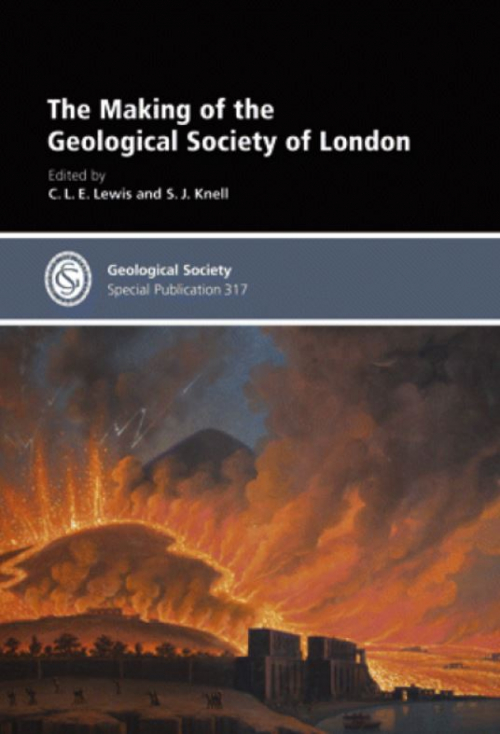
The modern image of the Geological Society owes much to William Smith whom the Society used, in 1831, to claim ascendency over European rivals. At its birth, however, the Society pursued a science adopted from the Continent, which privileged field data and saw mineralogy and chemistry as the sciences of the Earth. The Society’s birth mobilized the nation; its co-operative, mobile, investigative, subtly theoretical and didactic vigour materialized in the production of Greenough’s geological map of England.
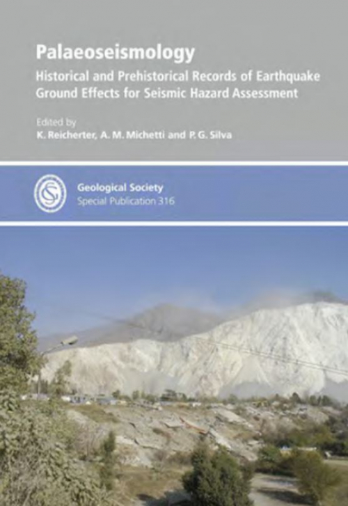
Earthquakes are one of the greatest natural hazards humans face. During the twentieth century alone, over two million people died during strong ground shaking, attendant fires, tsunamis and landslides. Most recently, in May 2008, about 80 000 people died in an earthquake in Sichuan Province in China and, earlier, on 26 December 2004, more than 200 000 people lost their lives to the tsunami resulting from the great earthquake off the west coast of Sumatra in Indonesia. In December 2003, the ancient city of Bam in Iran was destroyed by an earthquake, with the loss of over 30 000 lives. The worst disaster in modern times occurred in China in July 1976, when an entire city was destroyed and over 240 000 people killed in less than six minutes. Earlier, in 1556, an earthquake in north-central China killed an estimated 800 000 people, one of the worst natural disasters in recorded history. <...>
THIS VOLUME is in three parts. Part I contains the text of papers given at the symposium meeting; in this sense it is what is generally understood by a symposium in that each paper is the responsibility of the author, who although invited to contribute in a particular field has nevertheless decided for himself how to do this. It thus consists of a series of loosely related papers. Part II, on the other hand, is an integrated compilation, and the introduction explains how this effort in documentation was organized. It does not comment, however, on the labour which made this publication possible;
Many geologists, particularly those in industry, have commented adversely on the adequacy of university geology courses as a realistic precursor to a vocational career in any branch of the earth sciences other than in the universities themselves. This volume, among other things, is evidence that university staff are concerned about this situation and are introducing the reality, stringency and urgency of industry into areas where, until recently, they have been absent or poorly represented. In this context the study of volcanic processes belongs almost entirely to academics, whereas ore genesis, although a fascinating intellectual subiect, is of prime concern to the mining industry.
The First Working Party Report (Anon. 1982) defined 'Land surface evaluation' for engineering practice as: 'The evaluation and interpretation of land surface features and recorded surface data using one or a combination of the ground mapping, interpretation, classification and visual remote sensing techniques outlined in this report'. The techniques outlined in the report were land classification, remote sensing and geomorphological mapping.
Faults are important controls on hydrocarbon migration and ore mineralization and, in areas of active deformation, are the most important source of seismic hazard. However, faults are rarely discrete surfaces and the internal structure of fault zones (e.g., the thickness, nature and continuity of the fault rocks, the distribution and segmentation of slip surfaces, and the orientation, distribution and connectivity of subsidiary faults and fractures) is a key control on their bulk fluid flow and mechanical properties.