Добрый день, Коллеги. Важное сообщение, просьба принять участие. Музей Ферсмана ищет помощь для реставрационных работ в помещении. Подробности по ссылке

Поиск по книгам
Автор(ы):Bagherbandi M., Sjoberg L.E.
Издание:Springer, 2017 г., 390 стр., ISBN: 978-3-319-50297-7
Язык(и)Английский
Gravity inversion and integration. Theory and applications in geodesy and geophysics / Инверсия гравитации и интеграция. Теория и применение в геодезии и геофизике

The task of this book is to convey some basic and in-depth knowledge on the traditional and recent theory of gravity inversion and integration for applications in geodesy and geophysics. The subject fields, physical geodesy and geophysics including geodynamics with emphasis on gravity information, are briefly introduced. Also the recent history of physical geodesy and gravimetric geophysics is reviewed. It follows that satellite techniques are indispensable for global to regional studies. The basic but important concepts of a geodetic reference system, frame and datum are also defined with examples. The Geodetic Reference System 1980, a versatile tool in most applications of gravity data, is presented in some detail. <...>

Автор(ы):Dube B., Gosseli P.
Издание:2007 г., 13 стр.
Язык(и)Английский
Greenstone-hosted quartz-carbonate vein deposits (orogenic, mesothermal, lode gold, shear-zone-related quartz-carbonate or gold-inly deposits) / Кварц-карбонатные жилы в зеленокаменных породах (орогенные, мезотермальные, золоторудные жилы ...)

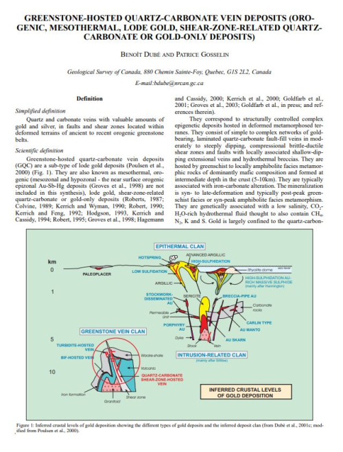
Simplified definition Quartz and carbonate veins with valuable amounts of gold and silver, in faults and shear zones located within deformed terrains of ancient to recent orogenic  reenstone belts. Scientific definition Greenstone-hosted quartz-carbonate vein deposits (GQC) are a sub-type of lode gold deposits (Poulsen et al., 2000) (Fig. 1). They are also known as mesothermal, orogenic (mesozonal and hypozonal - the near surface orogenic epizonal Au-Sb-Hg deposits (Groves et al., 1998) are not included in this synthesis), lode gold, shear-zone-related quartz-carbonate or gold-only deposits (Roberts, 1987; Colvine, 1989; Kerrich and Wyman, 1990; Robert, 1990; Kerrich and Feng, 1992; Hodgson, 1993, Kerrich and Cassidy, 1994; Robert, 1995; Groves et al., 1998; Hagemann and Cassidy, 2000; Kerrich et al., 2000; Goldfarb et al., 2001; Groves et al., 2003; Goldfarb et al., in press; and references therein).

Редактор(ы):Chu J., Indraratna B., Rujikiatkamjorn C.
Издание:Elsevier, 2015 г., 810 стр., ISBN: 978-0-08-100192-9
Язык(и)Английский
Ground improvement. Case histories. Embankments with special reference to consolidation and other physical methods / Усиление грунтов. Исторические примеры. Насыпи с особым упором на укрепление и другие физические методы

There is hardly any country in the world that does not encounter problematic soil either due to natural formation or caused by manmade activities for land use and construction at a given location or at any given time. Moreover, with increasing population in many countries, it is almost inevitable that even the most marginal land and often difficult terrains are also utilised for infrastructure development.

Редактор(ы):Bristow C.S., Jol H.M.
Издание:The Geological Society of London, 2003 г., 338 стр., ISBN: 1-86239-131-9
Язык(и)Английский
Ground penetrating radar in sediments / Георадар при изучении осадочных отложений

In recent years, the use of ground penetrating radar (GPR) to investigate the shallow subsurface has transformed the study of sediments. GPR is now an accepted and widely applied tool for the earth scientist, enabling a non-destructive investigation of both modern and ancient sediments. Based on the rapid growth of this field, we organised an international research meeting entitled Ground Penetrating Radar (GPR) in Sediments: Applications and Interpretation that was held at the Geological Society of London and the University College of London in August 2001.

Издание:Sensors & Software Inc, 1999 г., 21 стр.
Язык(и)Английский
Ground Penetrating Radar. Survey design. Sensors and Software / Проникающий сквозь землю георадар. Проект обследования. Датчики и программное обеспечение

Ground penetrating radar (or GPR for short) is the general term applied to techniques which employ radio waves, typically in the 1 to 1000 MHz frequency range, to map structure and features buried in the ground (or in man-made structures). Historically, GPR was primarily focused on mapping structures in the ground; more recently GPR has been used in non-destructive testing of non-metallic structures. The applications are limited only by the imagination and availability of suitable instrumentation. <...>

Автор(ы):Hadjigeorgiou J., Potvin Y.
Издание:Australian Centre for Geomechanics, 2020 г., 270 стр., ISBN: 978-0-9876389-5-3
Язык(и)Английский
Ground support for underground mines / Крепление подземных горных выработок

Ground support has been used to stabilise underground excavations in rock since Roman times. In a review of the evolution of ground support and reinforcement, Brown (1999) refers to De Re Metallica (Agricola 1556), which describes timbering in shafts, tunnels and drifts used as a means of protection against collapse and risk of injury. Stabilisation of the immediate boundary of a rock mass surrounding an excavation is often referred to as ‘local support’. Until the 1950s, timbering remained one of the main means of local support. Since then, it has gradually been replaced by internal reinforcement techniques, such as dowels installed inside a drilled hole.

Издание:CRC Press, 2023 г., 441 стр., ISBN: 978-1-032-39972-0
Язык(и)Английский
Ground support technology for highly stressed excavations. Integrated theoretical, laboratory and field research / Технология крепления грунта при выемке грунта с высокой нагрузкой. Комплексные теоретические, лабораторные и полевые исследования

The continued and growing worldwide demand for minerals means that mining operations are being conducted at ever-increasing depths. Safe and efficient mineral extraction at depth is accompanied by significant engineering problems that require the modification of existing practices and the development and implementation of new technologies. This book is timely in that it attempts to address a particularly difficult problem—maintaining the stability of production and infrastructure excavations under changing static and dynamic conditions.

Редактор(ы):Adhikary P.P., Bhunia G.S., Dash C.J., Shit P.K.
Издание:Elsevier, 2021 г., 534 стр., ISBN: 978-3-030-64135-1
Язык(и)Английский
Groundwater and society. Applications of geospatial technology / Подземные воды и общество Приложения геопространственных технологий

Water is the basic requirement for the development of civilization. The primitive civilizations were developed along the surface water bodies to meet the demand of water for the society. With the progress of time, the population-led demand for water was increased in those civilizations and which ultimately led to conflicts. The Indus valley civilization was destroyed mainly because of issues related to water management.

Издание 3
Редактор(ы):Sterrett R.J.
Издание:Johnson screens, 2007 г., 798 стр., ISBN: 978-0-9787793-0-6
Язык(и)Английский
Groundwater and wells. A comprehensive guide for the design, installation and maintenance of a water well / Грунтовые воды и скважины. Полное руководство для проектирования, строительства и обслуживания скважин на воду

At the start of the twenty-first century, the demand for clean potable water is increasing at a greater rate due in part to a growing population. Additionally, societies are being forced to evaluate impacts on current and future water supplies as a result of energy and mineral development and climate changes. These evaluations include a determination of the quantity and quality of the groundwater resource.

Редактор(ы):Nordstrom D.K.
Издание:Springer, 2005 г., 206 стр., ISBN: 3-540-24195-7
Язык(и)Английский
Groundwater geochemistry. A practical guide to modeling of natural and contaminated aquatic systems / Геохимия грунтовых вод. Практическое руководство по моделированию исходных и загрязненных водных систем

To understand hydrochemistry and to analyze natural as well as man-made impacts on aquatic systems, hydrogeochemical models have been used since the 1960’s and more frequently in recent times.
Numerical groundwater flow, transport, and geochemical models are important tools besides classical deterministic and analytical approaches. Solving complex linear or non-linear systems of equations, commonly with hundreds of unknown parameters, is a routine task for a PC.

983.47