Добрый день, Коллеги. Важное сообщение, просьба принять участие. Музей Ферсмана ищет помощь для реставрационных работ в помещении. Подробности по ссылке
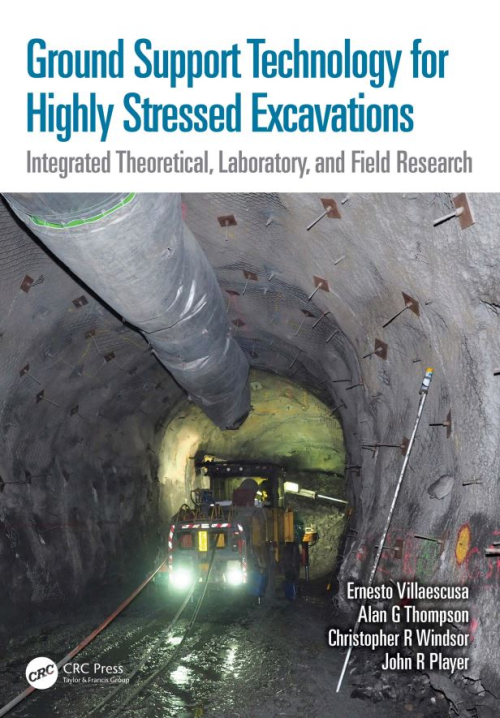
The continued and growing worldwide demand for minerals means that mining operations are being conducted at ever-increasing depths. Safe and efficient mineral extraction at depth is accompanied by significant engineering problems that require the modification of existing practices and the development and implementation of new technologies. This book is timely in that it attempts to address a particularly difficult problem—maintaining the stability of production and infrastructure excavations under changing static and dynamic conditions.
We perceive a trend in the study and practice of groundwater hydrology. We see a science that is emerging from its geological roots and its early hydraulic applications into a full-fledged environmental science. We see a science that is becoming more interdisciplinary innature and of greater importance in the affairs of mano This book is ourresponse to these perceived trends. We have tried to provide a text that is suited to the study of groundwater during this period of emergence. We have made a consCÍous attempt to integrate geology and hydrology, physics and chemistry, and science and engineering to a greater degree than has been done in the past.
Water is the basic requirement for the development of civilization. The primitive civilizations were developed along the surface water bodies to meet the demand of water for the society. With the progress of time, the population-led demand for water was increased in those civilizations and which ultimately led to conflicts. The Indus valley civilization was destroyed mainly because of issues related to water management.
The need for hydrological research, basic as well as applied, is substantial to help rationally manage the world’s water resources. To satisfy this need, and the interest of Member States, UNESCO, in 1975, launched a long-term intergovernmental programme, the International Hydrological Programme (IHP), to follow the first worldwide programme devoted to scientific study of the hydrological cycle, the International Hydrological Decade (1965–1974). Although the IHP is basically a scientific and educational programme, UNESCO endeavours to direct programme activities towards the practical solutions of the world’s very real water resource problems, while maintaining the IHP scientific concept <...>
To understand hydrochemistry and to analyze natural as well as man-made impacts on aquatic systems, hydrogeochemical models have been used since the 1960’s and more frequently in recent times. Numerical groundwater flow, transport, and geochemical models are important tools besides classical deterministic and analytical approaches. Solving complex linear or non-linear systems of equations, commonly with hundreds of unknown parameters, is a routine task for a PC.
Access to clean water is a human right and a basic requirement for economic development. The safest kind of water supply is the use of groundwater. Since groundwater normally has a natural protection against pollution by the covering layers, only minor water treatment is required. Detailed knowledge on the extent, hydraulic properties, and vulnerability of groundwater reservoirs is necessary to enable a sustainable use of the resources.
Many engineering projects, especially major ones, entail excavations into water-bearing soils. For all such excavations, appropriate system(s) for the management and control of the groundwater and surface water run-off should be planned before the start of each project. In practice, this can only be done with knowledge of the ground and groundwater conditions likely to be encountered by reference to site investigation data. The control of groundwater (and also surface water run-off) is invariably categorized as ‘temporary works’ and so is often regarded by the client and their engineer or architect as the sole responsibility of the contractor and of little or no concern to them. In many instances, this philosophy has been demonstrated to be short-sighted and ultimately costly to the client <...>
The International Hydrological Programme (IHP) is as an evolving programme, ready to adapt to the needs of an ever changing society. In order to respond promptly and with appropriate actions, the programme is implemented in six year phases, so as to identify new emerging problems, alert decision makers, raise public awareness and provide the necessary resources.
Today, integrated water resources management poses not only scientific, but also technical, socio-economic, cultural and ethical challenges. IHP is a multidisciplinary programme at the forefront of research and development; and to this end is a prominent agent in meeting the United Nations Millennium Goals.
Understanding of groundwater has developed significantly since 1972 when the first part of the original volume of Groundwater Studies was published by UNESCO. Yet for someone who is just commencing the study of groundwater, there is still a need for a text which will help in starting their work. For those with a greater experience in hydrogeological investigations, there is a need to increase awareness both of more recent work and information about techniques which are outside their previous experience. This new volume is intended to meet both of these needs and therefore it has the subtitle ‘An International Guide for Hydrogeological Investigations’.
This document was prepared in the framework of the Fourth Phase of the International Programme as Project M-1-3 that was supervised and directed by Habib Zebidi, Water Science Specialist, Division of Water Sciences, UNESCO and after his retirement in 1999 by his successor Ms Alice Aureli.
Dr Habib Zebidi has drawn contributors and members for an editing committee from different countries. They brought to this volume their own distinctive perspectives, for all are acknowledged experts with extensive experience of practical groundwater issues. The members of the editing committee have provided a certain unity of style end presentation and also they have tried to keep the size of this document in hand. Each chapter is intended to provide sufficient information to comprehend the fundamentals of the topic; in addition reference is made to publications where further information can be obtained for more detailed study. The contributing authors are listed below per chapter and details are given in Appendix A-3.
The Pamir–Tibet–Himalaya orogenic system (Fig. 1) has been growing as a consequence of the collision between the Eurasian and the Indian plates since the Early Eocene (e.g. Hodges 2000). While the time of formation and the magnitude of shortening across the Tibetan Plateau are relatively well constrained, its origin and evolution are disputed, untested, or unknown (e.g. Yin & Harrison 2000).