Добрый день, Коллеги. Важное сообщение, просьба принять участие. Музей Ферсмана ищет помощь для реставрационных работ в помещении. Подробности по ссылке

Поиск по книгам
Выпуск 90
Автор(ы):Ilchik R.P.
Издание:Economic geology, 1995 г., 3 стр.
Язык(и)Английский
40Ar/39Ar, K/Ar, and fission track geochronology of sediment-hosted dessiminated gold deposits at Post-Betza, Carlin Trend, Northeastern Nevada - a discussion

40Ar/39Ar, K/Ar и геохронология следов расщепления отложений в залежах истощенного золота в Пост-Бетце, Карлин-Тренд, Северо-Восточная Невада - обсуждение


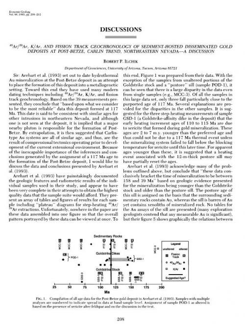
Arehart et al. (1993) set out to date hydrothermal Au mineralization at the Post-Betze deposit in an attempt to place the formation of this deposit into a metallogenetic setting. Toward this end they have used many modern dating techniques including 40Ar/39Ar, K/Ar, and fission track geochronology. Based on the 39 measurements presented, they conclude that "based upon what we consider to be the most reliable" data this deposit formed at 117 Ma. This date is said to be consistent with similar ages for other intrusions in northeastern Nevada, and although one is not seen at the deposit, it is implied that a major nearby pluton is responsible for the formation of Post-Betze. By extrapolation, it is then suggested that Carlin-type Au systems are all of similar age, and thus, are the result of compressional tectonics operating prior to development of the current extensional environment. Because of the inescapable importance of the inferences and conclusions generated by the assignment of a 117 Ma age to the formation of the Post-Betze deposit, I would like to discuss the data and conclusions presented by Arehart et al. (1993).

Выпуск 88
Издание:Economic geology, 1993 г., 25 стр.
Язык(и)Английский
40Ar/39Ar, K/Ar, and Fission Track Geochronology of Sediment-Hosted Disseminated Gold Deposits at Post-Betze, Carlin Trend, Northeastern Nevada

40Ar/39Ar, K/Ar и геохронология следа расщепления отложений вкрапленного золота в Пост-Бетце, Карлин-Тренд, Северо-Восточная Невада.


The Post-Betze deposit of Nevada is the largest sediment-hosted disseminated gold deposit presently known, both dimensionally and in terms of contained metal. Ore occurs primarily as submicron-sized gold that is disseminated in altered sedimentary rocks of the Lower Paleozoic Roberts Mountains Formation. However, significant portions of the ore are present in altered monzonite of the Goldstrike stock. Alteration and mineralization were controlled by both structure and stratigraphy. Alteration began with early decarbonatization and was followed by silicification and, finally, argillization. Phyllosilicate mineral zoning grades from proximal kaolinite to kaolinite + sericite to unaltered rock.

Выпуск 90
Издание:Economic geology, 1995 г., 3 стр.
Язык(и)Английский
40Ar/39Ar, K/Ar, and fission track geochronology of sediment-hosted disseminated gold depositsat at Post-Betze, Carlin Trend, Northeastern Nevada - a reply

40Ar/39Ar, K/Ar и геохронология следа расщепления отложений рассеянного золота в Пост-Бетце, Карлин-Тренд, Северо-Восточная Невада - ответ


We appreciate the comments on our paper on the Post-Betze sediment-hosted disseminated gold deposit which indicate that clarification is required. Ilchik suggests alternative interpretations of our findings with regard to two main issues: the nature of the sill that we have described as "postore," and the absolute age of Post-Betze mineralization in the context of the overall spread in the dates presented in our paper. We address these issues in turn.

Автор(ы):Gallois R., Hart M.
Издание:Plymouth University, Plymouth, 2009 г., 25 стр.
Язык(и)Русский
8th International Symposium on the Cretaceous System. Field excurion to Beer, South-East Devon (Jurassic coast world heritage site)

In 2001 the Dorset and East Devon Coast was inscribed on the World Heritage List as a place of outstanding universal value on the basis of its geological succession, coastal processes and landforms and its place in the history of the development of geology (especially stratigraphy and palaeontology). Extending from Orcombe Point in the west to Studland in the east, this World Heritage Site's 85 miles of coastline contains a record of 185 million years of Earth history. <...>

Издание:Plymouth University, Plymouth, 2009 г., 39 стр.
Язык(и)Английский
8th International Symposium on the Cretaceous System. Field Excursion to Dorset & Isle of Wight

In 2001 the Dorset and east Devon Coast was inscribed on the UNESCO World Heritage List as a place of outstanding universal value on the basis of its geological succession, coastal processes and landforms and its place in the history of the development of geology (especially stratigraphy and palaeontology). Extending from Orcombe Point in the west to Studland in the east, this World Heritage Site's 85 miles of coastline contains a record of 185 million years of Earth history. At the time of the proposal being submitted to UNESCO there were discussions about whether the planned site could be extended westwards to Torquay, covering the Permian and the Devonian rocks of Teignmouth, Dawlish and Torquay or eastwards to include the Isle of Wight. For various reasons (mostly non-geological) it was decided not to expand the proposed site further, although the Isle of Wight would have been the natural extension of the site, including more of the Cretaceous succession as well as the marine Cenozoic succession of the Hampshire Basin. This excursion is, in reality, looking at what the expanded site would have included.

Автор(ы):Thomas R.
Издание:2001 г., 79 стр.
Язык(и)Английский
A beginner’s guide to ICP-MS / Вводное руководство по ICP-MS

Amazingly, 18 years after the commercialization of inductively coupled plasma mass spectrometry (ICP-MS), less than 4000 systems have been installed worldwide. If you compare this number with another rapid multielement technique, inductively coupled plasma optical emission spectrometry (ICP-OES), first commercialized in 1974, the difference is quite significant. In 1992, 18 years after ICP-OES was introduced, more than 9000 units had been sold, and if you compare it with the same time period that ICP-MS has been available, the difference is even more dramatic.

Автор(ы):Nolet G.
Издание:Cambridge University Press, 2008 г., 359 стр., ISBN: 978-0-521-88244-6
Язык(и)Английский
A breviary of seismic tomography. Imaging the interior of the Earth and Sun / Основы сейсмотомографии. Визуализация Земли и Солнца

This is the first textbook to cover all the major aspects of seismic tomography at a level accessible to students. While focusing on applications in solid earth geophysics, the book also includes numerous excursions into helioseismology in order to demonstrate the strong affinity between the two fields. The book presents a comprehensive introduction to seismic tomography including the basic theory of wave propagation, the ray and Born approximations required for interpretation of amplitudes, travel times and phases, eigenvibrations and surface waves, observational methods, model parametrization, finite-frequency methods, inversion, error and resolution analysis, and seismic anisotropy. It presents in-depth consideration of observational aspects of the subject, as well as practical recommendations for implementing numerical models using publicly available software.

Автор(ы):Davis M.
Издание:Springer, 2021 г., 213 стр., ISBN: 978-3-030-84016-7
Язык(и)Английский
A cartographic analysis of soviet military city plans / Картографический анализ планов советских военных городов

The collapse of the Soviet Union has seen the emergence of its unprecedentedly comprehensive global military mapping programme and the commercial availability of a vast number of detailed topographic maps and city plans at several scales. This thesis provides an in-depth examination of the series of over 2,000 large-scale city plans produced by the Military Topographic Directorate (Boennoe topogpafiqeckoe yppavlenie) of the General Staff between the end of the Second World War and the collapse of the USSR in 1991. After positioning the series in its historical context, the nature and content of the plans are examined in detail.

ТематикаГеография
Автор(ы):Jones I.
Издание:12 стр.
Язык(и)Английский
A case study using indicator kriging - the Mount Morgan gold-copper deposit, Queensland / Тематическое исследование с использованием индикаторного кригинга - золото-медное месторождение Маунт Морган, Квинсленд

In August 1882, the Morgan brothers recognised a mineral deposit, now known as the Mount Morgan Gold-Copper Deposit. The final production figures for the mine were 250 tonnes of gold and 360,000 tonnes of copper from 50 million tonnes of ore, making the average grades 4.99g/t gold and 0.72% copper.

Автор(ы):Stel H, Veenhof R.P.
Издание:Elsevier, 1991 г., 14 стр.
Язык(и)Английский
A cleavage triple point and its meso-scopic structures: the Mustio Sink (Svecofennides of SW Finland)

Veenhof, R.P. and Stel, H.. 1991. A cleavage triple point and its meso-scopiс structures: the Mustio Sink (Svecofennides of SW Finland) Precambrian Res., 50: 269-282,

A cleavage-triple-point (CTP) structure is analyzed, located at the west side of the Mustio gneiss dome in the Svecofennides of southwest Finland. The presence of the CTP and the pattern of mesoscopic fold structures exclude the origin of the Mustio dome by successive interference of fold phases. The highly variable deformation structures are explained in a single-phase deformation model by using the theoretical specific strain environments ofa CTP. These environment are (1) horizontal oblation on lop ofa dome, (2) transition from horizontal to vertical obiation on ihe flanks ofa dome, and (3) vertical constriction in the center of the CTP, It is shown that each strain environment is associated with specific development of foliation, folds, mesoscopic fold interference and strain intensity. The theoretical strain environments are confirmed by strain analysis.


1094.82