Добрый день, Коллеги. Важное сообщение, просьба принять участие. Музей Ферсмана ищет помощь для реставрационных работ в помещении. Подробности по ссылке
Our understanding of folds and folding builds on detailed geometrical analysis. Proper description of folds and their relation to other structures such as fractures, cleavage and lineations form, together with physical and numerical modelling, the foundation for linking folds to stress, strain, kinematics, mechanics, and underlying tectonic processes. A large number of classification schemes and approaches have accumulated over the past century or so, and this overview critically considers a substantial portion of these schemes together with models for fold formation.
В книге изложена теория и практика геометрического картирования месторождений полезных ископаемых и геометрические методы решения ряда горнотехнических задач, способы подсчета и классификация запасов твердых полезных ископаемых при добыче.
В настоящее время перспективы наращивания минерально-сырьевой базы алмазодобывающего комплекса сегодня связываются, во-первых, с новыми перспективными районами со сложными условиями поисков, т.е. - территориями, где кимберлитовые тела перекрыты более поздними образованиями, а, во-вторых, с вероятностью обнаружения в известных кимберлитовых полях рудных тел, обладающих неконтрастными индикаторными характеристиками.
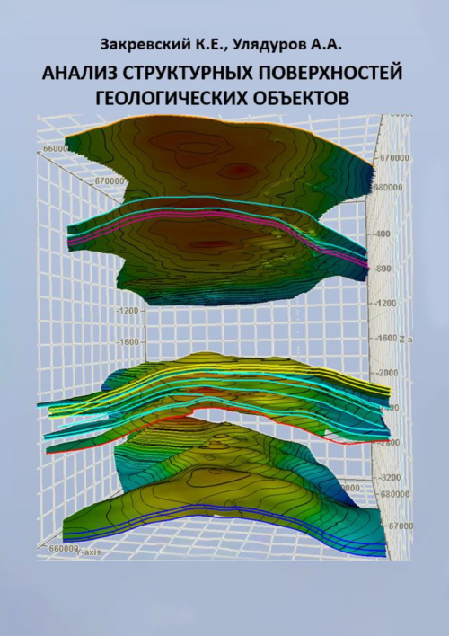
Рассмотрены вопросы анализа структурных поверхностей геологических объектов – залежей нефти и газа. Описаны методические и технологические подходы к анализу как поверхностей отдельных пластов, так и набора поверхностей для изучаемой совокупности пластов многопластовых месторождений.
Различные способы анализа структурных поверхностей (корреляционный, градиентный, вариограммный, спектральный, трендовый) описываются с привлечением большого количества фактического материала. Оценивается практическая применимость различных способов анализа структурных поверхностей для построения геологических моделей разного масштаба.
Представленную монографию можно использовать как методическое пособие для студентов вузов в рамках курса «Применение математических методов в геологии».
Авторы благодарны Лебедеву М. В. за рецензирование монографии и доведение ее до законченного и отредактированного вида.
В книге изложены методы геометризации резервуаров и залежей, обеспечивающие построение более вероятных моделей размещения нефти и газа в продуктивных отложениях. Большинство рекомендуемых методик апробировано и внедрено при подсчете и пересчете запасов высоких промышленных категорий с утверждением их в ГКЗ СССР, а также при разработке различных по типу залежей нефти и газа.
Книга рекомендуется для широкого круга специалистов, занимающихся поиском, разведкой и разработкой залежей нефти и газа, а также подготовкой подземных хранилищ различного назначения и разработкой программ для ЭВМ с целью решения отдельных задач нефтепромысловой геологии. Она представляет интерес и для студентов геологической специальности в освоении практических навыков нефтепромысловой геологии.