Добрый день, Коллеги. Важное сообщение, просьба принять участие. Музей Ферсмана ищет помощь для реставрационных работ в помещении. Подробности по ссылке
About 2,200 years ago a scholarly librarian in charge of the prestigious collections of the museum at Alexandria conducted an elegant exercise in logic and experimentation. Using seemingly unrelated bits of information such as the observation of the penetration of sunlight into a well in the city of Syene, the speed of a camel caravan, and the shadow cast by an obelisk in Alexandria, Eratosthenes calculated a remarkably accurate estimate of the circumference of the earth (Wilford 1981).
When computers were frst invented in the middle of the last century, nobody ever anticipated that the instruction sets to program them would ultimately evolve to the point where many of them could be accessed freely, without charge, in ways that would become widely available to nonexpert communities. Nor did we ever consider that computers would penetrate every corner of social life, revolutionizing our social behavior, our science, and our politics.
What is cartography today? When I look back on the first and second editions of this book, it’s almost like seeing cartography as it progressed since 2009 and it now looks almost nothing like it did then. The expansion of what’s possible has been incredible. Massive technological change, accompanied by free, open, highly detailed, and reliable datasets, along with a surge of interest in the field from all corners, combined to make what was once impossible cartographically, possible.
The spontaneous potential well-logging is one of the most common and useful welllogging techniques in petroleum exploitation. Since the earth layer can be regarded as a piecewise uniform medium, and due to electrochemical and other factors, there exists a jump of potential (spontaneous potential difference) on each interface of different layers.
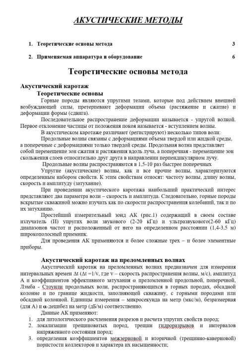
Горные породы являются упругими телами, которые под действием внешней возбуждающей силы, претерпевают деформации объема (растяжение и сжатие) и деформации формы (сдвига).
Последовательное распространение деформации называется - упругой волной. Первое отклонение частицы от положения покоя называется - вступлением волны.
В акустическом каротаже различают (регистрируют) несколько типов волн:
QGIS is a crossing point of the free and open source geospatial world. While there are a great many tools in QGIS, it is not one massive application that does everything, and it was never really designed to be that from the beginning. It is rather a visual interface to much of the open source geospatial world. You can load data from proprietary and open formats into spatial databases of various flavors and then analyze the data with well-known analytical backends before creating a printed or web-based map to display and interact with your results. What’s QGIS’s role in all this? It’s the place where you check your data along the way, build and queue the analysis, visualize the results, and develop cartographic end products. This learning path will teach you all that and more, in a hands-on learn-by-doing manner. Become an expert in QGIS with this useful companion. <...>
Geography has always been important to humans. Stone-age hunters anticipated the location of their quarry, early explorers lived or died by their knowledge of geography, and current societies work and play based on their understanding of who belongs where. Applied geography, in the form of maps and spatial information, has served discovery, planning, cooperation, and conflict for at least the past 3000 years (Figure 1-1). Maps are among the most beautiful and useful documents of human civilization.
This book is an introduction to critical cartography and GIS. As such, it is neither a textbook nor a software manual. My purpose is to discuss various aspects of mapping theory and practice, from critical social theory to some of the most interesting new mapping practices such as map hacking and the geospatial web. It is an appreciation of a more critical cartography and GIS.
If those of us in the geographic information system (GIS) realm have disregarded design in the past, we are now coming to realize that the elegant display of geographic data is as important as the data itself. Some resistance may be introduced when we talk about making a map look pretty; and rightly so. But elegance in mapping goes well beyond making a map look attractive. In this text, I explain exactly how to convey information to serve up the facts, hold the viewer’s attention, avoid potential confusion, and provide all the necessary metadata. Even with no prior experience in cartography, you can learn how to create maps with these qualities by studying these pages. Let’s begin. <...>
GIS Applications in Agriculture, Volume Four: Conservation Planning, edited by Tom Mueller and Gretchen F. Sassenrath, is the fourth volume in the book series GIS Applications in Agriculture, which is designed to enhance the application and use of geographic information systems (GISs) in agriculture by providing detailed GIS applications that are useful to scientists, educators, students, consultants, and farmers. The first volume, GIS Applications in Agriculture, edited by Francis J. Pierce and David Clay, was published by CRC Press in 2007. The second volume, GIS Applications in Agriculture: Nutrient Management for Improved Energy Efficiency, edited by David Clay and John Shanahan, and the third volume, GIS Applications in Agriculture: Invasive Species, edited by Sharon Clay, were published by CRC Press in 2011. While the newest book in this series, the idea of a book on conservation planning using GIS was identified in 2007 when the book series began. Intuitively, conservation planning through GIS applications should appeal to all conservationists who clearly understand that a key to achieving soil and water conservation is rooted in an understanding of the spatial and temporal variation in both soil and water resources and natural and human-induced forces that affect the quality and quantity of those resources. <...>