Добрый день, Коллеги. Важное сообщение, просьба принять участие. Музей Ферсмана ищет помощь для реставрационных работ в помещении. Подробности по ссылке
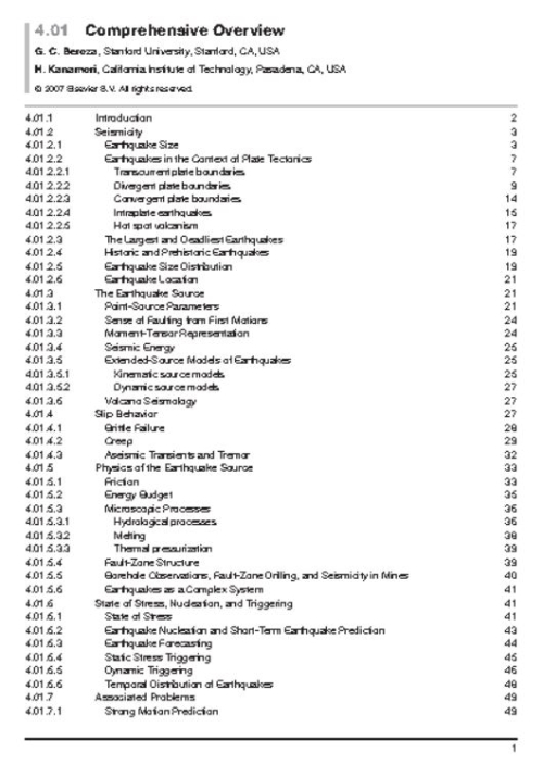
In general usage, the term ‘earthquake’ describes a sudden shaking of the ground. Earth scientists, however, typically use the word ‘earthquake’ somewhat differently – to describe the ‘source’ of seismic waves, which is nearly always sudden shear slip on a fault within the Earth (see Figure 1). In this article, we follow the scientific usage of the term, and focus our review on how earthquakes are studied using the motion of the ground remote from the earthquake source itself, that is, by interpreting the same shaking that most people consider to be ‘the earthquake’. The field defined by the use of seismic waves to understand earthquakes is known as earthquake seismology. The nature of the earthquakes makes them intrinsically difficult to study. Different aspects of the earthquake process span a tremendous range in length scales – all the way from the size of individual mineral grains to the size of the largest plates. They span a tremendous range in timescales as well. The smallest micro-earthquakes rupture faults for only a small fractionof a second andthe durationof even the verylargest earthquakes can be measured in hundreds of seconds. Compare this with the length of strain accumulation in the earthquake cycle, which can be measured in decades, centuries, and even millenniums in regions of slow strain rate. The evolution of fault systems spans longer times still, since that can require the action of thousands of earthquakes. At different physical dimensions or temporal scales, different physical mechanisms may become important, or perhaps negligible. Earthquakes occur in geologically, and hence physically, complicated environments. The behavior of earthquakes has been held up as a type example of a complex natural system. The sudden transformation of faults from being locked, or perhaps slipping quasistatically, to slipping unstably at large slip speeds, as is nearly universally observed for earthquakes, also makes them a challenging physical system to understand. Despite these challenges, seismologists have made tremendous progress in understanding many aspects of earthquakes – elucidating their mechanisms based on the radiated seismic wavefield, determining where they occur and the deep structure of faults with great precision, documenting the frequency and the regularity (or irregularity) with which they occur (and recur) over the long-term, gaining insight into the ways in which they interact with one another, and so on. Yet, the obvious goal of short-term prediction of earthquakes, that is specifying the time, location, and size of future significant earthquakes on a timescale shorter than decades, remains elusive. Earthquakes are different in this sense from nearly all other deadly natural hazards such as hurricanes, floods, and tornadoes, and even volcanic eruptions, which to varying degrees are predictable over a timescale of hours to days. The worst earthquakes rank at the very top of known disasters. The deadliest known earthquake killed over half a million people in a matter of minutes.
Modern geodesy as discussed in this volume started with the development of distance measurement using propagating electromagnetic signals and the launch of Earth-orbiting satellites. With these developments, space-based geodesy allowed global measurements of positions, changes in the rotation of the Earth, and the Earth’s gravity field. These three areas (positioning, Earth rotation, and gravity field) are considered the three pillars of geodesy. The accuracy of current measurement systems allows time variations to be observed in all three areas. Also the complexity of problems is such that each of the pillars interacts with each other and also with many other branches of Earth Science. This interaction is most apparent in the role that water plays in modern geodetic measurements. Every chapter in this volume mentions the role of water. It is critical because it can move rapidly and over large distances; it can exist in all three phases, gas, fluid, and solid; and modern geodetic methods are accurate enough that their measurements are sensitive to its effects. In its vapor form, its refractive properties delay microwave signals propagating through the Earth’s atmosphere. For geodetic positioning, this is a noise source but it is a signal for metrological applications. In the liquid form, it forms oceans that affect both the tidal signal and the rotation of the Earth. Also in liquid form, its mass changes the gravity field as it is moved through the hydrologic cycle. In solid form, it has a gravitational and deformation signal that changes if melting of the ice unloads the surface of the Earth. The interactions between the pillars include the elastic loading effects of changing mass loads that can be seen in the gravity field and in the positions of ground stations. The movement of water to and from the oceans can be seen with altimeter satellites whose orbital information is derived from measurements from ground stations whose positions are affected by the changing mass load. In modern, time-dependent geodetic data analysis these interactions need to be accounted for. The common interface between the geodetic methods is the coordinate systems and reference frames used to analyze data. Coordinate systems and the associated reference frames form a core theme of the chapters in this volume. Two other unifying themes are the measurement systems of geodesy that are used again throughout the volume, and interplay of errors in measurements, signals, and noise. In this chapter weexamine these three themes.
Mineral physics involves the application of physics and chemistry techniques in order to understand and predict the fundamental behavior of Earth materials (e.g., Kieffer and Navrotsky, 1985), and hence provide solutions to large-scale problems in Earth and planetary sciences. Mineral physics, therefore, is relevant to all aspects of solid Earth sciences, from surface processes and environmental geochemistry to the deep Earth and the nature of the core. In this volume, however, we focus only on the geophysical applications of mineral physics (see also Ahrens (1995), Hemley (1998), and Poirier (2000)). These applications, however, are not just be constrained to understanding structure the Earth (see Volume 1) and its evolution (see Volume 9), but also will play a vital role in our understanding of the dynamics and evolution of other planets in our solar system (see Volume 10 and Oganov et al. (2005)). As a discipline, mineral physics as such has only been recognized for some 30 years or so, but in fact it can trace its origins back to the very foundations of solid Earth geophysics itself. Thus, for example, the work of Oldham (1906) and Gutenberg (1913), that defined the seismological characteristics of the core, led to the inference on the basis of materials physics that the outer core is liquid because of its inability to support the promulgation of shear waves. A landmark paper in the history of the application of mineral physics to the understanding of the solid Earth is the Density of the Earth by Williamson and Adams (1923). Here the elastic constants of various rock types were used to interpret the density profile as a function of depth within the Earth that had been inferred from seismic and gravitational data. Their work was marked by taking into account the gravitationally induced compression of material at depth within the Earth, which is described by the Williamson–Adams relation that explicitly links geophysical observables (g(r), the acceleration due to gravity as a function of radius, r, and the longitudinal and shear seismic wave velocities Vp and Vs).
Geophysics is the physics of the Earth, the science that studies the Earth by measuring the physical consequences of its presence and activity. It is a science of extraordinary breadth, requiring 10 volumes of this treatise for its description. Only a treatise can present a science with the breadth of geophysics if, in addition to completeness of the subject matter, it is intended to discuss the material in great depth. Thus, while there are many books on geophysics dealing with its many subdivisions, a single book cannot give more than an introductory flavor of each topic. At the other extreme, a single book can cover one aspect of geophysics in great detail, as is done in each of the volumes of this treatise, but the treatise has the unique advantage of having been designed as an integrated series, an important feature of an interdisciplinary science such as geophysics. From the outset, the treatise was planned to cover each area of geophysics from the basics to the cutting edge so that the beginning student could learn the subject and the advanced researcher could have an up-to-date and thorough exposition of the state of the field. The planning of the contents of each volume was carried out with the active participation of the editors of all the volumes to insure that each subject area of the treatise benefited from the multitude of connections to other areas. Geophysics includes the study of the Earth’s fluid envelope and its near-space environment. However, in this treatise, the subject has been narrowed to the solid Earth. The Treatise on Geophysics discusses the atmosphere, ocean, and plasmasphere of the Earth only in connection with how these parts of the Earth affect the solid planet. While the realm of geophysics has here been narrowed to the solid Earth, it is broadened to include other planets of our solar system and the planets of other stars. Accordingly, the treatise includes a volume on the planets, although that volume deals mostly with the terrestrial planets of our own solar system. The gas and ice giant planets of the outer solar system and similar extra-solar planets are discussed in only one chapter of the treatise. Even the Treatise on Geophysics must be circumscribed to some extent. One could envision a future treatise on Planetary and Space Physics or a treatise on Atmospheric and Oceanic Physics. Geophysics is fundamentally an interdisciplinary endeavor, built on the foundations of physics, mathematics, geology, astronomy, and other disciplines. Its roots therefore go far back in history, but the science has blossomed only in the last century with the explosive increase in our ability to measure the properties of the Earth and the processes going on inside the Earth and on and above its surface. The technological advances of the last century in laboratory and field instrumentation, computing, and satellite-based remote sensing are largely responsible for the explosive growth of geophysics. In addition to the enhanced ability to make crucial measurements and collect and analyze enormous amounts of data, progress in geophysics was facilitated by the acceptance of the paradigm of plate tectonics and mantle convection in the 1960s. This new view of how the Earth works enabled an understanding of earthquakes, volcanoes, mountain building, indeed all of geology, at a fundamental level. The exploration of the planets and moons of our solar system, beginning with the Apollo missions to the Moon, has invigorated geophysics and further extended its purview beyond the Earth. Today geophysics is a vital and thriving enterprise involving many thousands of scientists throughout the world. The interdisciplinarity and global nature of geophysics identifies it as one of the great unifying endeavors of humanity.
Данная книга предназначена для специалистов по оценке запасов, особенно, для новичков в построении их моделей. На основе ряда полетных советов и подсказок, она ставит целью помочь вам ускорить изучение процесса оценки запасов, уделяя особое внимание последствиям принимаемых решений, нежели математике или геостатистике как таковым.
Мне было интересно работать с большим разнообразием видов полезных ископаемых, залегающих в самых различных геологических условиях по всему миру. И что самое главное, работа в горнодобывающей промышленности позволила мне познакомиться с увлекательным миром заверки достоверности модели путём сравнения с фактическими производственными показателями. Возможность создания модели запасов, следование ей в процессе добычи и её заверки обеспечивают реальное изучение порядка и последовательности работы её компонентов.
Strata-bound Cu- (Ag) deposits, long known as 'Chilean manto-type', occur along the Coastal Cordillera of northern Chile (22°-30°S) hosted by Jurassic and Lower Cretaceous volcanic and volcano-sedimentary rocks. These deposits are typical of the first stage of Andean evolution characterised by an extensional setting of the arc magmatism along the active margin of South America. Strata-bound Cu- (Ag) deposits were formed during two metallogenic epochs in the Late Jurassic and uppermost Early Cretaceous. The mineralisation took place at the time of structurally controlled emplacement of batholiths within the Mesozoic volcanic and sedimentary strata. The volcanic-hosted strata-bound Cu- (Ag) deposits invariably occur distal, but peripheral to coeval batholiths emplaced within tilted Mesozoic strata. The prevalent view that these deposits have an inherent genetic relationship with hydrothermal fluid derivation from subvolcanic stocks and dykes is contended here, because these minor intrusions are largely barren and this hypothesis does not fit well with Sr, Os and Pb isotopic data that call for crustal contribution of these elements. The strata-bound Cu- (Ag) mineralisation appears to be produced by fluids of mixed origin that were mobilised within penneable levels and structural weakness zones of the Mesozoic arc-related volcano-sedimentary sequence during the emplacement of shallow granodioritic batholiths under transtensional regimes. These hydrothermal fluids deposited copper and subordinate silver when reacted with organic matter, pyrite and/or cooled away from their heat sources. Although strata-bound Cu- (Ag) mineralisation took place during the same Cretaceous metallogenic event that formed the magnetite-apatite bodies, and Fe-oxide-Cu-Au deposits along the present Coastal Cordillera, the conceivable relationships with these other types of deposits are hampered by the inconclusive debate about the origin of the Chilean Fe-oxide deposits. However, the available data strongly suggest that the Fe oxide-rich deposits are metasomatic in origin and genetically related to contact zones of Lower Cretaceous dioritic batholiths, whereas the iron-poor volcanic-hosted Cu-(Ag) stratabound deposits constitute distal mineralisation peripheral to Upper Jurassic of Lower Cretaceous granodioritic batholiths.
El Soldado is the largest (>200 Mt @ 1.4% Cu) of the known Cu manto-type deposits in central Chile. It is strata-bound within a submarine, bimodal calc-alkaline basalt - rhyodacite unit of the Lower Cretaceous Lo Prado Formation., which also contains marine carbonaceous shales and volcaniclastic sandstones. Although stratigraphically restricted, the clustered orebodies are mostly vein-like and discordant, controlled by a system of N-S to NNW faults fonned within a transtensional zone (cymoid loop) of a sinistral, strike-slip brittle shear system. Individual orebodies are zoned, with an external and deeper zone of barren pyrite, followed inward by concentric zones with chalcopyrite-pyrite, chalcopyrite bornite, bornite-chalcocite, and a central zone of chalcocite (± digenite ± covellite) and abundant hematite. The deposit was formed in two main phases: l)a low-temperature, diagenetic phase during which framboidal pyrite developed in association with migrated petroleum, at ca. 130 to 120 Ma; 2) a high-temperature (>300°C from fluid inclusions) hydrothennal phase at ca. 103 Ma, (coinciding with batholith emplacement), that deposited early hematite (± magnetite), followed by chalcopyrite, bornite and chalcocite, mostly replacing pre-existing pyrite, with the excess Fe forming hematite. Gangue minerals are calcite, albite, k-feldspar and chlorite. The hydrothermal Cu mineralization is associated with an increase in Na and depletion in K in host rocks, although there are localised zones of K increase in bornite-chalcocite assemblages near structures. Isotopic studies indicate that: a) the sulphur in diagenetic pyrite provided the bulk of the sulphur for Cu sulphides; b) petroleum was the source of carbon in bitumen and part of the carbonate; c) osmium in diagenetic pyrite was derived from the black shales; d) strontium in calcites was inherited from the Cretaceous arc lavas; e) oxygen isotopes in carbonates, and K-feldspar and atmospheric argon in K-feldspar plus the high salinity of fluid inclusions (21-26% NaCl equivalent) suggest a basinal connate-metamorphic brine was responsible for Cu transport, yet a (distal) magmatic component to the fluids cannot be ruled out.
The Arizaro and Lindero prospects are possibly the youngest recognised examples of the hydrothermal iron oxide-copper-gold class of deposits in the world. These two prospects, and numerous other iron-oxide manifestations, form a newly discovered district within northwest Argentina. The Arizaro and Lindero prospects are hosted within mid-Miocene, calc-alkaline, dominantly andesitic, volcanic complexes that formed within a convergent plate margin tectonic setting. This descriptive paper presents observations from surface geology and petrographic studies.
The Productora prospect is situated 15 km SSW of the town of Vallenar in the Third Region, north-central Chile. It lies within the "Chilean Iron Belt" close to the north-trending Atacama Fault system. The belt contains a variety of Fe oxide ±Cu ±Au-bearing deposits including Candelaria (366 million tonnes averaging 1.08 % Cu, 0.26 g/t Au) which is situated in the Punta del Cobre region approximately 150 km north of Productora. The age, structural setting, alteration assemblages and styles of mineralisation in the Productora area resemble those present at Candelaria, but Productora differs in its spatial association with intrusive rocks and its lack of skarn assemblages.
Located approximately 400 km south of Lima, Peru, the Marcona and Pampa de Pongo deposits are the largest iron accumulations with associated copper and gold along the western coast of South America. Approximate resources include more than 1400 Mt of iron ore at Marcona and 1000 Mt of magnetite mineralisation at Pampa de Pongo. Both deposits contain some copper and gold and exhibit numerous features that allow their inclusion in the "Iron Oxide-Copper-Gold" clan of deposits, alongside such examples asCandelaria and Mantos Blancos in Chile. The two deposits form part of a cluster of similar occurrences that together define the "Marcona Fe-Cu District".