Добрый день, Коллеги. Важное сообщение, просьба принять участие. Музей Ферсмана ищет помощь для реставрационных работ в помещении. Подробности по ссылке
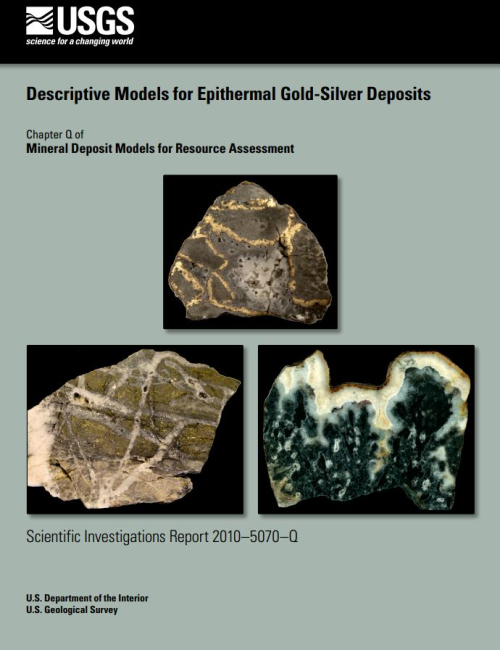
This report constitutes a new descriptive model for epithermal gold-silver deposits. It summarizes characteristics of known deposits, including their geological, geophysical, geochemical, and geoenvironmental aspects. Models concerning the genesis of epithermal gold-silver deposits are discussed. How descriptive and genetic aspects of the model can be applied to mineral exploration and resource assessment of undiscovered deposits is described.
Deserts provide an excellent subject for interchange between Earth scientists of differing subdisciplines. The aridity of climate and the sparseness of plants and animals, especially Man, encourage surface processes that produce sedimentary deposits sufficiently distinctive to be recognized unequivocally both throughout the passage of time and from one planet to another. Because of this, and because Lyell's dictum of uniformitarianism is probably most appropriate in desert settings where the impingement of evolving life forms has been least, an exchange between scientists concerned with the living deserts of Earth and beyond, on the one hand, and with ancient Earth counterparts, on the other, is extremely fruitful. Lessons are learned on all sides. This was the spirit that encouraged 185 participants to gather at a Special Scientific Meeting of the Geological Society of London in May 1986. It is also the underlying rationale for this Special Publication which incorporates a substantial proportion of the contributions made at that Meeting. <...>
In a broad sense, what one attempts to do in rock engineering is to anticipate the motion of a proposed structure under a set of given conditions. The main design objective is to calculate displacements, and as a practical matter, to see whether the displacements are acceptable. Very often restrictions on displacements are implied rather than stated outright. This situation is almost always the case in elastic design where the displacements of the structure of interest are restricted only to the extent that they remain within the range of elastic behavior. <...>
Geological hazard and the lack of appropriate survey, design and construction instruments for tackling those terrains we call “difficult”, with good prospects of success, have always made the design and construction of underground works a risky affair, which could not therefore be faced with the same degree of accuracy as other civil engineering works. As a consequence they have always occupied a subordinate position with respect to similar surface constructions and in the past they were only resorted to when the latter seemed impractical or of little use.
The material presented in this publication has been prepared in accordance with recognized engineering principles. This Standard and Commentary should not be used without first securing competent advice with respect to their suitability for any given application. The publication of the material contained herein is not intended as a representation or warranty on the part of the American Society of Civil Engineers, or of any person named herein, that this information is suitable for any general or particular use or promises freedom from infringement of any patent or patents. Anyone making use of this information assumes all liability from such use.
This document provides an overview of the Deswik.CAD object model and scripting interface. The document does cover some specifics of the programming and vb language uses, but is not designed as an in depth programming reference. The Deswik Scripting language closely follows the VB.NET Framework 4 as much as possible. Bearing in mind that it does NOT execute the code in the .NET JIT compiler (it has its own compiler). For this reason it is possible to use the Microsoft VB.NET web resources when looking for syntax information. There are likely some code syntaxes and methods which Deswik has not encountered. Should you find one of these cases please contact support and we will rectify as quickly as possible. <...>
Мы понимаем, что некоторые участники курса Deswik «Проектирование карьеров для добычи металлов» могут быть новичками в проектировании карьеров и нуждаться в рекомендациях по выполнению проекта.
Эта статья написана с учетом этой потребности и предназначена специально для помощи в компьютерном проектировании карьеров, то есть в руководстве по геометрическому проектированию. Она не претендует на полноту охвата общих принципов проектирования и эксплуатации карьеров.
This tutorial provides an introduction to the common tools and functions contained within Deswik.CAD in an Open Pit Hard Rock operation, however as this tutorial is an introduction to Deswik.CAD functionality, the learning’s can be applied generally.
This tutorial is designed to be used in conjunction with the training data folder 3.01 Intro to CAD Open Pit Hard Rock containing all of the training data, software files and a completed set of CAD exercises. <...>
This tutorial provides an introduction to the common tools and functions contained within Deswik.Scheduler in an Underground Hard Rock Operation, however as this tutorial is an introduction to Deswik.Scheduler functionality, the learning’s can be applied generally.